
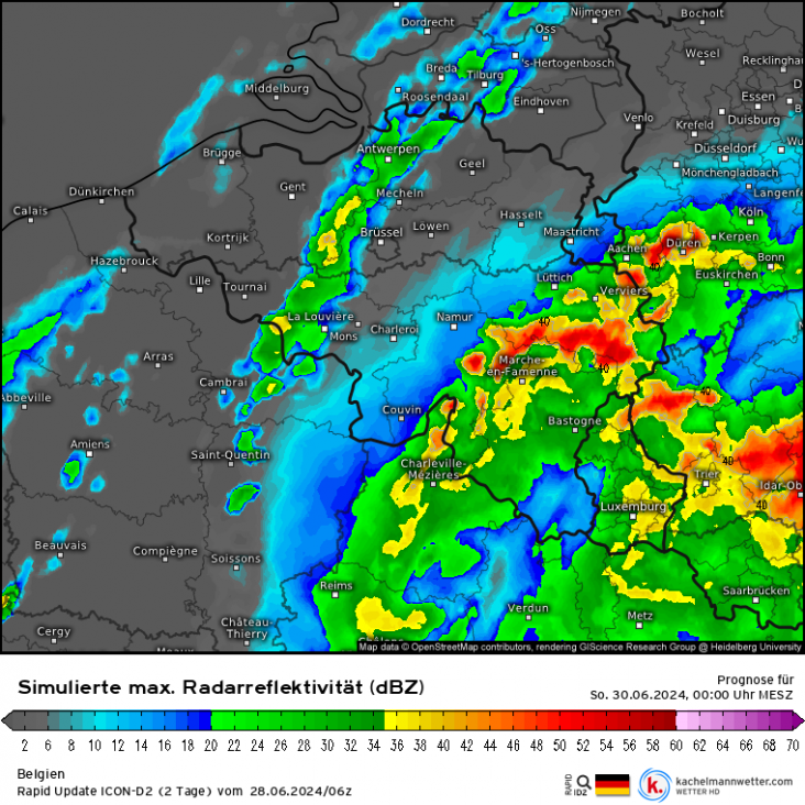
Stabiele lucht aan de grond, onstabiele lucht op hoogte
Deze zin uit de guidance wil ik wat meer toelichten. Zaterdagavond stijgen de CAPE-waarden boven Zuid-Limburg tot 1000 J/kg, maar deze onstabiele lucht is niet merkbaar aan de grond. Dit komt doordat er een warmtefront boven het zuidoosten van Nederland komt te liggen.CAPE-waarden boven het zuiden van Limburg in de avond rond 1000 J/kg, deze zit echter boven de 7000 vt.
Uit de theorie weten we misschien nog dat een warmtefront vaak schuin staat. Warme lucht glijdt over de koude lucht. In dit geval gaat morgen in de loop van de dag boven het zuidoosten warme, vochtige en dus onstabiele lucht over de koudere lucht heen glijden. Hierdoor wordt in Zuid-Limburg boven de 7000 voet (2 km hoogte) onstabiele lucht aangevoerd met CAPE-waardes tot 1000 J/kg.
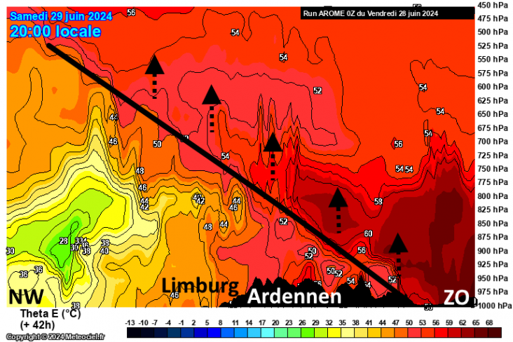
Ten zuidoosten van de Ardennen & Eifel bereikt het warmtefront de grond en kunnen de buien vanaf de grond gevoed worden. Boven Limburg ligt het front echter al op circa 800 hPa (2 km).
Deze onstabiele lucht heeft verschillende gevolgen:
- In het warmtefront (wat voornamelijk uit een pakket hoge en middelbare bewolking bestaat) kunnen ingebedde buien met wat onweer voorkomen.
- Het onweertype zal eerder hoogteonweer zijn, met een grotere afstand tussen de wolkenbasis en de grond (en dus minder inslagen).
- Pas ten zuidoosten van de Eifel/Ardennen krijgen buien onstabiele lucht vanaf de grond. Door de extra energie is er daar kans op zware windstoten, grote hagel en zware regenval.
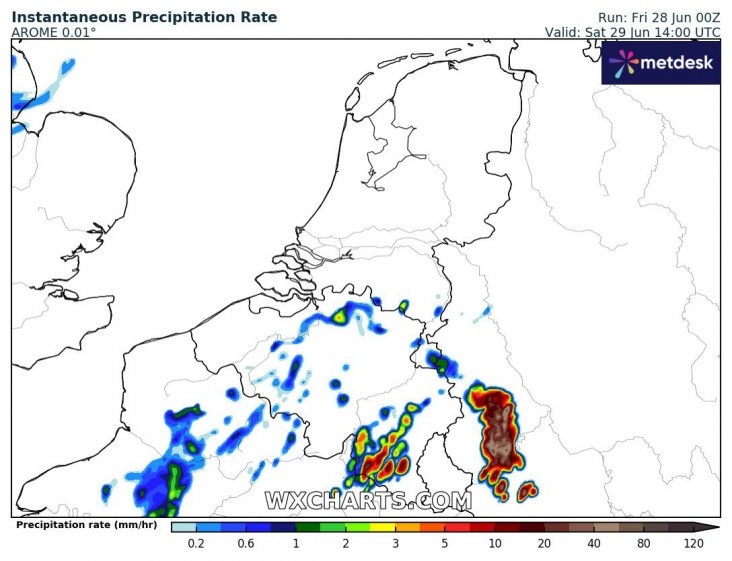
Verreweg de meeste buien lijken allemaal boven de Ardennen en Duitsland te blijven, maar een kleine koerswijziging zou ertoe kunnen leiden dat Zuid-Limburg toch wel zware buien meepikt.
Mogelijk krijgt ook Limburg een deel van deze zware convectie mee, met in Zuid-Limburg mogelijk wateroverlast. Er is nog wel wat onzekerheid of de zware buien Limburg zullen treffen, de afgelopen runs afgelopen runs hebben de neiging om alles steeds een tikkeltje oostelijker te laten uitkomen.
Zaterdagmiddag: 1ste kleine portie buien over Ardennen
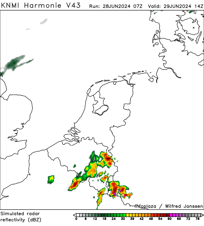
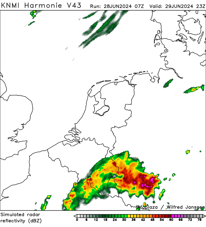
Avond en nacht naar zondag: MCS over Duitsland
 | Gewijzigd: 28 juni 2024, 12:05 uur, door Thijs.
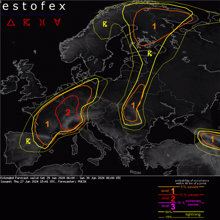
Extended Forecast
Valid: Sat 29 Jun 2024 06:00 to Sun 30 Jun 2024 06:00 UTC
Issued: Thu 27 Jun 2024 15:41
Forecaster: PUCIK
A level 2 was issued across E France, W to central Germany, Switzerland and NW Italy mainly for damaging wind gusts and large to very large hail.
A level 1 was issued across N Spain, France, Belgium and N Germany mainly for severe wind gusts, large hail and heavy rainfall.
A level 1 was issued across Finland and N Russia mainly for severe wind gusts and tornadoes.
A level 1 was issued across Caucasus mainly for large hail.
DISCUSSION
... France, Germany, Switzerland, NW Italy ...
A regional severe weather outbreak is likely, especially across the area under the Lvl 2.
A sharp short-wave trough is forecast to eject from NE Spain on Saturday morning and move across S France into Germany, weakening and deamplifying. Ahead of the short-wave a wavy frontal boundary will stretch from France into Germany and S Poland. As the trough crosses the region, the frontal system will shift NE-wards, crossing the region by Sunday morning.
Within the warm sector, a plume of steep mid-tropospheric lapse rates will develop across the Alps and cover E France, Switzerland and S/SW Germany. With low-level moisture locally exceeding 14 g/kg, fat CAPE profiles with MLCAPE values ranging from 2 to 4.5 kJ/kg are forecast. Strong vertical wind shear will overlap with the high CAPE, with 0-6 km bulk shear ranging from 20 to 30 m/s and 0-3 km shear ranging from 15 to 25 m/s.
Intense and well-organised storms, including supercells and bow-echoes are likely in this environment with threats of very large hail and damaging wind gusts. Storm coverage will increase rapidly towards 15 UTC. Given strong forcing, widespread storms are likely, especially in a belt from E France through W Switzerland into W Germany. Here, a Lvl 3 may be required in the next outlook for a swath of severe to extremely severe wind gusts.
More isolated convective mode will be possible across N and N Italy, located further away from the strongest lift. More detailed convective mode and associated severe weather threat forecast will likely come with the next outlook, when high-resolution model output will be available for the region.
ICON D2, reflectivity for Saturday. pic.twitter.com/qkB69VGHmu
— Leo (@some_maps) June 28, 2024
| Gewijzigd: 28 juni 2024, 15:12 uur, door Thijs.
Vrijdag kleine kans op een beetje onweer langs oostgrens
Vanuit het zuiden trekt vrijdag een lagedrukgebied over de Benelux heen. Vooral vrijdagochtend, met name langs de oostgrens van Limburg & de Achterhoek, is er kans op enkele onweersbuien. Dit zijn elevated onweersbuien, dankzij een overlap tot 500 J/kg CAPE met 25-30 knopen schering. Organisatietype is multicell.
In die rode pitjes in Limburg zou vrijdagochtend misschien al een beetje onweer voor kunnen komen. Het gaat om elevated onweer, geen kans op hagel, windstoten of hoge bliksemintensiteit.
Het grootste deel beleeft een koele, grijze en vrij regenachtige vrijdag. Op veel plaatsen valt er enige tijd stratiforme lichte tot matige neerslag. 's Ochtends is het in het noorden nog net eventjes droog, elders is het slechts af en toe kort eventjes droog. Langs de oostgrens in de neerslag meer convectief.
In intensieve langdurige neerslag kan het afkoelen naar amper 16 graden, in het noorden is het als het 's ochtends nog droog is nog 17-18 graden. Langs de oostgrens kan het nog kort eventjes warmer dan 20 graden worden (voordat het daar weer terug afkoelt).

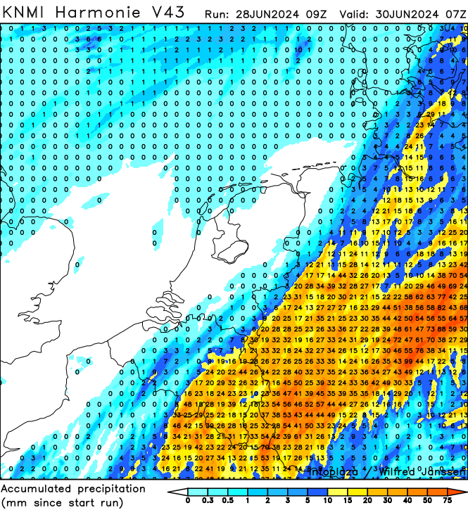
Er kan zo'n 5 tot 20 mm vallen, plaatselijk kan er zelfs meer dan 30 mm vallen. De regio met de meeste neerslag loopt in de modellen nog sterk uiteen, vergelijk hieronder maar Harmonie met ICON-D2. Dit is geheel afhankelijk van de exacte koers van het laag & bijbehorende buien.


| Gewijzigd: 11 juli 2024, 10:45 uur, door Thijs.Vrijdag in de frontale zone perioden met regen (met de genoemde onzekerheid), in de nacht en ochtend met voorkeur voor het zuidoosten en oosten. Daar zie we ook wat potentiële onstabiliteit in de progtemps, maar CAPE is beperkt. Er is een kleine kans op onweer in met name Zuid-Limburg op de langstrekkende golf in de nacht naar vrijdag of vrijdagochtend vroeg (ca. 20% volgens EC-EPS). Elders is de onweerskans nog kleiner. In Harmonie zien we op passage van de hoogtetrog echter ook in het westen sporadisch een ontlading, dit is een aandachtspunt.
Ander aandachtspunt is de neerslagsom, in Harmonie zien we langs de oostgrens plaatselijk ca. 40 mm, EC is daar met 10-20 mm beduidend minder uitbundig.
Hier een kort antwoord van mij.
Komende dagen is naast CAPE ook de CIN belangrijk. Hieronder de afkortingen in het kort:
| CIN | Convective Inhibition | Convectieve remming |
| CAPE | Convective Available Potential Energy | Potentieel beschikbare convectieve energie |
De vochtigheid en temperatuur variëren met hoogte. Momenteel stroomt er erg vochtige lucht binnen in de luchtlaag vlakbij de grond. Morgen hebben we echter ook nog een luchtlaag daarboven die erg droog is.
Morgen zal iedere poging van een stapelwolk die wil uitgroeien tot bui hierdoor stranden. De droge luchtlaag bevindt zich namelijk precies op de hoogte waar de stapelwolk normaal tot onweersbui uit kan groeien. Op die hoogte zal de stapelwolk nu drogere lucht tegenkomen en daardoor oplossen. Het blijft daardoor morgen nog lang strakblauw.
Ondanks een hoge CAPE houdt een CIN (negatieve CAPE) de buienvorming dus tegen. De P in CAPE staat voor potentie, die in dit geval morgen dus niet benut gaat worden. Staar je dus niet blind op de CAPE waardes, dat is slechts één van de ingrediënten voor onweer. De andere ingrediënten ontbreken morgen.

Tussen 1 en 3 km zit morgen een laag met droge lucht, hierdoor ontstaan er geen buien, ondanks warme en vochtige lucht in de 0-1 km laag.
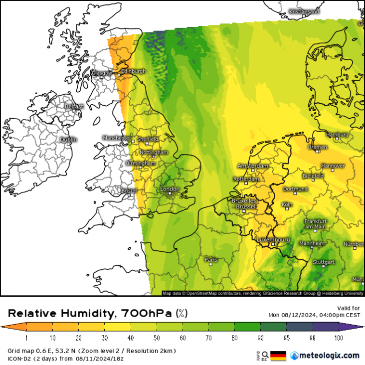
De temperaturen op 700 hPa (circa 3 km hoogte). In gele en oranje kleuren de laag droge lucht waarin stapelwolken geen kans krijgen te groeien.
Vanuit het westen meer kansen op onweer
Op bovenstaand plaatje zie je het al een beetje, boven het zuidwesten en West-Vlaanderen wordt maandagavond de lucht ook op 1-3 km hoogte vochtiger. Hierdoor laat een enkel model (arome) maandagavond al buien in het zuidwesten zien. De grote meerderheid houdt het dan nog droog.
Dinsdag meer kans op buien, want dan verdwijnt die droge laag die stapelwolken tegenhoudt. Type buien: single-cell, traag en plaatselijk veel regen (of wat hagel). Weinig windschering dus kans op supercellen en langlevende onweerscomplexen is klein. Later meer.

Met een westelijke stroming is de lucht op 1-3 km hoogte vochtiger geworden.
Aan de grond wordt de stroming dinsdag ook westelijk, dus daardoor wordt de warme en vochtige lucht aan de grond juist op transport gezet richting het oosten. De grootste kans op buien gaat daarmee richting Duitsland. Binnen de Benelux maakt de oostelijke helft de grootste kans, maar in Duitsland zijn de omstandigheden beter.

Tot zover de eerste inschatting. Als er nog onduidelijkheden zijn na dit (misschien wat rommelige) bericht, stel vooral je vraag.