Fagradalsfjall vulkaan barst opnieuw uit!
Ja, je leest het goed, een nieuwe zomervakantie, een nieuwe uitbarsting. De vorige uitbarsting vond plaats in 2022, van 3 tot 21 augustus. Ook deze uitbarsting valt precies in het toerisme seizoen. Tussen de huidige en de vorige uitbarsting (2022) zat 323 dagen, tussen de uitbarsting van 2021 en 2022 zat 319 dagen. Toeval? Mogelijk.De vorige uitbarsting was vrij kort. Inschattingen van de magmabel die nu aan het oppervlak is gekomen wijzen er ook op dat dit een relatief korte uitbarsting zou kunnen worden. De duur blijft echter onzeker, want mocht er een directe toevoer van vers magma uit de mantel ontstaan, dan kan de uitbarsting (veel) langer duren.
De uitbarsting
De meeste uitbarstingen in deze regio van IJsland starten als spleeteruptie. Deze uitbarsting ook, er is nu een 900 meter lange spleet geopend, uit deze spleet spuiten relatief kleine lavafonteinen. De uitbarsting heeft plaatsgevonden iets ten noordoosten van de vorige uitbarstingen, de verwachtingen zijn dat het grootste deel van de lava nog steeds naar het zuiden zal stromen. Omdat de uitbarsting midden op het onbewoonde schiereiland plaatsgevonden heeft, zal de lava de komende tijd ver uit de buurt van bewoning en infrastructuur (wegen, kabels) blijven.
Een terugblik: kwam de uitbarsting onverwachts?
De afgelopen weken namen de aardbevingen al toe. Hier een terugblik hoe de magmabel zich een weg door de aardkorst heen baande, en hierbij aardbevingszwermen veroorzaakten:
1 Juli - nieuwe magmabel ("magma intrusion") ontdekt
Gedurende de maand juni namen de aardbevingen onder het Reykjanes schiereiland steeds verder toe. Aan het einde van de maand bevestigde de IJslandse vulkanologische dienst dat er inderdaad een nieuwe magmabel onderweg naar het oppervlak was. Het was nog spannend of de magmabel al in de aardkorst ging stollen, of dat het tot aan het oppervlak zou geraken. Van de 8 magmabellen bereikten de afgelopen jaren slechts 2 het oppervlak.
Onderstaand filmpje gaat vanaf 1:15 over Fagradalsfjall, het eerste stuk kan je skippen.
8 juli - magmabel stijgt
Eerdere inschattingen gingen ervan uit dat de magmabel nog op 12 kilometer diepte zat, en nog een lange weg door de aardkorst moest afleggen. Maar toen kwamen er maarliefst 3000 aardbevingen voor op een diepte van 3-4 kilometer. Dat wees er dus op dat er een magmabel in hoog tempo naar het aardoppervlak onderweg was. Maar, soms stoppen magmabellen slechts honderden meters onder het aardoppervlak, dus de kans op een uitbarsting werd nog conservatief op 68% geschat. De inschatting van de locatie blijkt nu echt heel goed te kloppen.
| Sill | Een ondergrondse horizontale "plas" aan magma |
|---|---|
| Dike | Naar het Nederlandse woord "dijk", een verticale scheur gevuld met bijv. magma |
| Intrusion | Het binnendringen van een magmabel in de aardkorst |
| Gewijzigd: 13 juli 2023, 21:05 uur, door James Bob
Uitbarsting 2023 krachtiger dan 2021 en 2022, maar misschien nóg korter?
Wanneer een magmabel naar het oppervlak komt, kan het vervolgens langzaam leeglopen. De lavastroom is dan heel klein, maar kan wel maanden aanhouden (2021). De magmabel kan aan het oppervlak ook heel snel leeglopen. De lavastroom is dan eerst heel groot, maar na dagen of weken neemt de uitbarsting snel af (2022). De huidige 2023 uitbarsting is momenteel nóg krachtiger dan 2022, de spleet (fissure) werd in korte tijd snel groter, van enkele tientallen meters werd hij binnen een paar uur 1100 meter lang. De uitbarsting bestaat uit twee spleten waar magmafonteinen borrelen. Omdat de magmabel nu zo snel leegloopt, zou de uitbarsting binnen enkele dagen ook weer in omvang kleiner kunnen worden. Dat is nog onzeker.Gezien het risico dat nieuwe lavaspleten onder je voeten openen, is het nog niet toegestaan om binnen een circa 5 km radius van de vulkaan te komen.
Lavaspleet sluit steeds verder; later mogelijk nieuwe lavaspleten?
De vulkaan is nu open voor toeristen! Uiteraard moeten alle bezoekers zich wel bewust zijn van de risico's die er aan een vulkaanbezoek kleven. Een man moest eerder al gered worden nadat hij buiten bewustzijn raakte, dit kwam doordat hij dwars door de giftige vulkanische gassen liep.Hoe ziet de vulkaan er nu uit?
Er is veel rook in de omgeving, de rook wordt veroorzaakt door de giftige gassen uit de vulkaan, en door het smeulende mos dat bedekt wordt met hete lava. Het smeulende mos verspreidt zich steeds verder, dit komt doordat het in IJsland al enkele dagen stabiel en droog is, maar een stevige wind wakkert het brandende mos af en toe ook nog aan.
De lavaspleet was de vorige update nog haast 1000 meter, maar momenteel sluit hij steeds verder. Er zijn nog maar een paar openingen, en op die openingen vormt zich een kegel waar een kleine lavafontein is. De totale lavastroom is steeds verder af aan het nemen, de huidige lavastroom is nog maar 13% van de lavastroom op de eerste dag. Echter zit er volgens vulkanologen nog steeds een groot volume aan magma onder de grond. Te herkennen aan aardbevingen kan het ook zo zijn dat de ondergrondse magmaspleet zich ook een stuk naar het noorden aan het uitbreiden is. Het is daarom mogelijk dat er nog nieuwe lavaspleten gaan openen, want deze uitbarsting heeft nog steeds potentie.
Hoe ziet een openende spleetvulkaan eruit?
Deze vulkaanuitbarsting begon met in hoog tempo groeiende spleetvulkanen, waaruit lava begon de borrelen. Na de eerste spleet, opende er een klein stukje verderop een nieuwe spleet. De lavavelden van beide spleten kwamen elkaar snel tegen.
Op dit filmpje zie je dat de eerste spleet al geopend is. Langs het bestaande lavaveld zie je een spleet waar eerst heel veel gas uit komt, en vervolgens zie je precies de eerste lava uit de spleet omhoog borrelen. Al snel zijn de twee lavavelden samengevoegd tot één, maar je ziet nog wel de twee lijnen aan lavafonteinen. Bijzondere beelden!
| Spatter cone | Een vulkaankegel die vormt door het opspatten van lava, heet ook wel een sintelkegel of scoria-kegel. Vaak tussen de 10 en 500 meter hoog |
|---|---|
| Subsidence | Doe toestand waarbij de grond langzaam daalt |
Kegelinstorting Fagradalsfjall ook in beeld
Jakob Vegerfors brengt ook belangrijke gebeurtenissen rond de vulkaan in IJsland mooi in beeld. Het lijkt net alsof hij 24 uur per dag met de drone er rondvliegt, want hij maakte ook al prachtige beelden van de openscheurende lavaspleet. Nu dus beelden van de instorting van de noorwestelijke deel van de vulkaankegel (spatter cone). De vulkaankegel is bijna 40 meter hoog. Lava stroomt nu ook aan de andere kant van de vulkaan naar buiten, waardoor het heel misschien ook een noordwestelijke koers kan nemen richting de noordelijke kust van het schiereiland. Tot nu toe stroomde de lava richting het zuiden, de lava is al zover dat het nu de lavavelden van de 2022 uitbarsting bereikt heeft.
Hotel en spabaden IJsland ontruimd om vrees voor vulkaanuitbarsting
Van NOS.nl <= klik hier om meer te lezen.Een van de drukstbezochte toeristische plekken in IJsland, de Blue Lagoon Spa, is tijdelijk gesloten vanwege het risico op een vulkaanuitbarsting. Gasten die in de buurt van de baden in een kuuroord zaten, moesten in het holst van de nacht hun spullen pakken. De vrees is dat de vulkaan bij de berg Thorbjörn gaat uitbarsten.
Waarschuwingen:
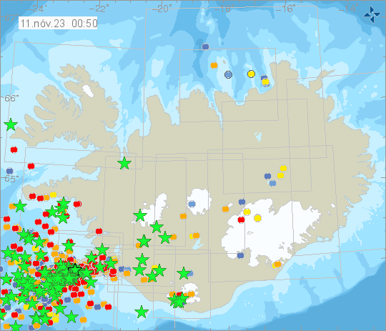
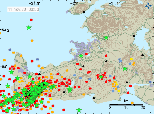
Na al zeker 2 weken seismische onrust in het gebied lijkt er nu een plotselinge versnelling in te zitten. Eerder vandaag begon een nieuwe aardbevingszwerm, net als afgelopen weken al vaker gebeurde, met enkele honderden aardbevingen, waarvan enkele boven de kracht van 3. Sinds het middaguur is echter het aantal aardbevingen drastisch gestegen. Op het Reykjanes schiereiland hebben de laatste 48 uur al meer dan 2.000 aardbevingen plaatsgevonden, waarvan verreweg de meeste in de laatste 12 uur. Bijna 250 daarvan zijn boven de kracht van 3. Het zijn er zelfs zoveel dat de overzichtskaart ze niet meer goed kan plaatsen:
Overzichtskaart aardbevingen IJsland:
Aardbevingen kaart op het Reykjanes schiereiland:
Tijd-tabel wanneer de aardbevingen plaatsvonden:

Hieronder de nieuwsberichten (in het Engels) van het IJslands Meteorologisch instituut van vandaag.
Te beginnen met de normale dagelijkse update van begin van de middag, nog voor de escalatie:
Updated 10. November at 2pm
Earlier today, at 12:44, an earthquake of magnitude 4.1 occurred near Sýlingarfell, west of Sundhnjúkagígar. The craters are about 2-3 km northeast of Grindavík. A dense swarm of earthquakes began around 07:00 this morning in the same area, and nearly 800 quakes have been recorded since midnight, including 9 greater than magnitude 3. The depth of the earthquakes is about 5 km. Such earthquake swarms have previously been recorded in this area. It cannot be ruled out that the seismic activity near Sundhnjúkagígar is due to magma movements at depth.
Magma accumulation continues near Þorbjörn at the same depth and at a similar rate as before. It is accompanied by swarm-like seismic activity, as was noticed yesterday and this morning. While magma accumulation continues, ongoing seismic activity can be expected due to stress release in the area. Earthquakes up to magnitude M5.5 can be expected in such swarms, and the seismic activity may shift between areas. At this stage, there are no indications that magma is forcing its way to the surface.
Eerste extra update aan het begin van de avond:
Updated 10. November at 6:30pm
The National Commissioner of the Icelandic Police, in consultation with the Police Commissioner of Suðurnes, has declared a Civil Protection Alert Phase due to the intense earthquake swarm that commenced 3pm today at Sundhnjúkagígar, north of Grindavík. There is the possibility for larger earthquakes than have been experienced thus far, and this sequence of events could lead to an eruption. The Civil Protection Alert Phase means that the risk is increasing, and measures are being taken to ensure the utmost safety of those who live/stay in the area. This is done by increasing precautions in the relevant area.
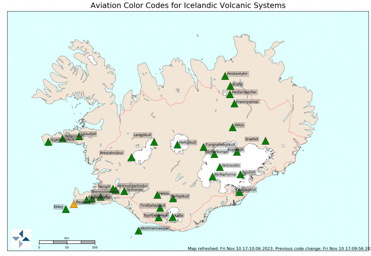
The Aviation Color Code has been elevated to orange (heightened unrest with increased likelihood of eruption). IMO is closely monitoring the situation. Residents are encouraged to follow the information provided on Almannavarnir.
Volgende update:
Updated 10. November at 8pm
The seismic activity currently measured at Sundhnjúkagígar occurs within an area about 3 km northeast of Grindavík. The shallowest earthquakes measured now are at a depth of about 3-3.5 km.
The signs that can be seen now at Sundhnjúkagígar are similar to those seen on the eve of the first eruption at Fagradalsfjall in 2021 and are very similar to the seismic activity that was measured about a month before that eruption. The most likely scenario now, taking into account the activity that culminated in the onset of the March 19th 2021, is that it will take several days (rather than hours) for magma to reach the surface.
Meest recente update:
Magma intrusion possibly extending beneath Grindavík
Civil Protection authorities declare emergency Level. Residents of Grindavík are advised to proceed with caution.
10.11.2023
Updated 10. November at 11:30pm
Significant changes have occurred in the seismic activity measured near Sundhnjúkagígar north of Grindavík and deformation observed in the Reykjanes Peninsula this afternoon. The seismic activity has moved south towards Grindavík. Based on how the seismic activity has evolved since 6 PM today, along with results from GPS measurements, there is a likelihood that a magma intrusion has extended beneath Grindavík. In light of this outcome, the police chief in Suðurnes, in cooperation with the Civil Protection Authorities, has decided to evacuate Grindavík. An emergency level of civil protection is now in effect. This is not an emergency evacuation. Residents of Grindavík are advised to proceed with caution.
At this stage, it is not possible to determine exactly whether and where magma might reach the surface. There are indications that a considerable amount of magma is moving in an area extending from Sundhnjúkagígum in the north towards Grindavík. The amount of magma involved is significantly more than what was observed in the largest magma intrusions associated with the eruptions at Fagradalsfjall. Further data is being collected to calculate models that provide a more accurate picture of the magma intrusion. It is currently not possible to say when this work will be completed.
De updates zijn hier te vinden:
https://en.vedur.is/about-imo/news/a-seismic-swarm-started-north-of-grindavik-last-night
Korte video van YouTube kanaal "Just Icelandic" over de situatie:
Eddy. | Gewijzigd: 13 november 2023, 15:06 uur, door flyineddy1
Svartsengi vulkaan barst uit bij Grindavík
We hebben beelden van een nieuwe vulkaanuitbarsting. De uitbarsting heeft plaatsgevonden op de meest waarschijnlijke plek, een eindje ten noorden van het dorpje Grindavík. Zolang er geen nieuwe lavaspleten openen, stroomt de lava pas op termijn richting Grindavík. Dat de lavastromen uiteindelijk wel rond Grindavík uitkomen is echter wel waarscijnlijk.. Gedurende het begin van de uitbarsting is de kans echter wel groot dat er nog meer lavaspleten gaan openen. Het openen van nieuwe lavaspleten blijft altijd lastig onvoorspelbaar (en zou in een absoluut worst case ook in het dorp kunnen plaatsvinden).
Tip: op de webcam kan je (nu nog) terugspoelen naar het moment dat de eerste lava aan het oppervlak komt. Dat is een spectaculair beeld, eerst was er niets en toen ineens een lavafontein (van vermoedelijk minstens tientallen meters hoog).
Lava stroomt uit 4 kilometer lange spleet
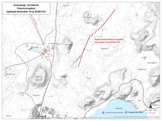
Updated 19 December at 3:00The intensity of the volcanic eruption, which started about four hours ago, is decreasing. This is evident from seismic and GPS measurements. The fact that the activity is decreasing already is not an indication of how long the eruption will last, but rather that the eruption is reaching a state of equilibrium. This development has been observed at the beginning of all eruptions on the Reykjanes Peninsula in recent years.
The eruptive fissure is about 4 km long, with the northern end just east of Stóra-Skógfell and the southern end just east of Sundhnúk. The distance from the southern end to the edge of Grindavík is almost 3 km.
The Icelandic Meteorological Office continues to monitor the activity and is in direct contact with civil protection and response units in the area. A meeting of scientists will be held tomorrow morning to evaluate the overnight development of the eruption.
This news will be updated at 09:00 on 19 December.
Volgende update is er nog niet. Bron: https://en.vedur.is/about-imo/news/a-seismic-swarm-started-north-of-grindavik-last-night
Intensiteit uitbarsting duidelijk afgenomen
Na een vliegende start vannacht, waarbij in korte tijd de spleet aanzienlijk langer werd en een vrij groot gebied (4 vierkante km) snel bedekt raakte, de intensiteit van de uitbarsting nu afgenomen.Van de originele 4 kilometer lange - vrijwel aaneengesloten - spleet, zijn nu slechts nog een paar secties actief. Dat zijn vooral secties aan de noordelijke helft van de spleet, de zuidelijke helft (dichterbij Grindavík) is minder actief. Er kan echter nog veel gebeuren dus er is nog steeds grote kans op een potentiële ramp voor het dorp Grindavík.
Little activity at the southern end of the fissure
Updated 19 December at 14:30 UTC
The size of the volcanic eruption at Sundhnúksgígar continues to diminish. The lava flow is estimated to be about one-quarter of what it was at the beginning of the eruption on 18 December, and a third of the original fissure is active. The lava fountains are also lower than at the start of the eruption, reaching about 30 meters at their highest. These figures are based on visual estimates from a reconnaissance flight early on 19 December.
The development of the eruption is similar to recent eruptions at Fagradalsfjall, where the fissures are starting to contract and form individual eruption vents. Presently, there are about five eruption vents spread along the original fissure.
According to information from scientists who went on a second helicopter flight with the Icelandic Coast Guard at around 04:00 UTC today, the total length of the fissure eruption has not changed much from the beginning. There was little activity at the southern end of the fissure near Hagafell, and the majority of the lava flow is heading east towards Fagradalsfjall. Two streams reach west, both north of Stóra-Skógfell.
At the time of publication, the volcanic plume is drifting from the west and northwest. Gas pollution might be noticeable in Vestmannaeyjar today, but not elsewhere in populated areas. According to the weather forecast, gas pollution might be detected in the capital area late tonight or tomorrow morning.
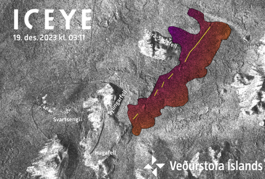
Amplitude image from an ICEYE satellite acquired at 03:11 this morning (19 Dec. 2023). Preliminary analysis of this image show the new eruptive fissure (yellow line) and lava flow (colored area). Notice that he dams built around Svartsengi are clearly visible.
Helicopter view of the eruption today from https://t.co/0UHTLm024f
— Volcaholic 🌋 (@volcaholic1) December 19, 2023
I wonder which bit will end up being the main focus. It’s sooo exciting 💃💃💃 pic.twitter.com/HHEuqzLQpa
Lavastroom met 90% afgenomen
Updated 19 December at 18:30 UTCThe eruption continues to weaken. New aerial images of the area show that there are now three vents erupting southeast of Stóra-Skógfell, down from the previous five. The lava has mostly flowed east from the eruption site, but there is also a lava tongue flowing west from the region north of Stóra-Skógfell.
Since the eruption began, about 320 earthquakes have been measured over the magma channels. The largest earthquake, with a magnitude of 4.1, occurred at 23:25 on Monday. After midnight, seismic activity significantly decreased, and since 12:00 today, only 10 earthquakes have been recorded in the region. Following the eruption at Sundhnúksgíga, the land in Svartsengi subsided more than 5 cm. Previously, the land had risen there by about 35 cm since the formation of the magma channel on November 10. It is too early to determine if magma will continue to accumulate under Svartsengi and whether the land will start to rise again.
While the eruption continues at Sundhnúksgíga, there is an increased likelihood that more vents may open along the original fissure as well as further north or south. Looking back at the lead-up to the eruption reveals that there were approximately 90 minutes between the first indicators and the start of the eruption. Therefore, the warning time for new vent openings at Sundhnúk could be very short.
Omdat ik de weg een beetje kwijtraak met al die onbekende IJslandse plaatsnamen, hieronder een klein overzicht. De huidige uitbarsting hoort bij het Svartsengi-vulkaansysteem. De vorige uitbarstingen behoorden tot het Fagradallsfjall-vulkaansysteem. Bij Svartsengi ligt de "blue lagoon" (toeristenatttractie) en een belangrijke energiecentrale die de warmte van de vulkaan gebruikt.
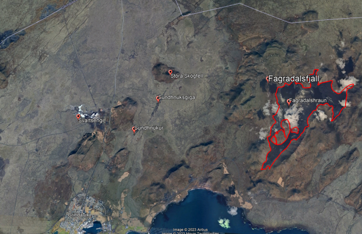
Paar toponiemen:
- hraun = Lavaveld
- gíga = kraters
- fjall = berg
- stora = groot
Zijn dit alweer de laatste dagen?
De uitbarsting is verder afgenomen, daarmee wordt het nu de vraag of deze uitbarsting de kerst gaat halen. Voortekenen tonen een snel einde, maar het gedrag van vulkanen blijft weinig voorspelbaar.Icelandic Met Office
In the last 24 hours, the highest activity in the eruption has remained around the middle of the fissure that opened on 18 December. Seismic activity has been relatively steady, and there have been little changes in deformation since the eruption began. Considering this, the Icelandic Meteorological Office (IMO) assesses that the likelihood of a new eruption forming without warning nearby Grindavík has decreased. It should be noted that although the likelihood of vent formation within Grindavík has decreased, the hazard level in that area is nevertheless considered substantial. Even though the activity has decreased since the eruption began, the intensity of the eruption is still significant and comparable to eruptions at Fagradalsfjall. It has also been shown that the magma can reach the surface quickly, leaving little time to issue warnings.
https://en.vedur.is/about-imo/news/a-seismic-swarm-started-north-of-grindavik-last-night
Is de uitbarsting voorbij?
Er is geen stromende lava meer zichtbaar aan het oppervlak. Er is echter nog wel een oranje gloed zichtbaar, mogelijk komt dit doordat lava nog wel door ondergrondse tunnels heen stroomt. We kunnen daarom nog niet met zekerheid zeggen dat de uitbarsting voorbij is.No visible eruptive activity
However, it is possible that there is lava flow in closed channels. The earthquake activity continues to decrease
Scientists who flew over the eruption site this morning confirm that no eruptive activity is visible and that lava flow from the craters seems to have ceased. Glowing is still visible in the lava field, possibly within closed channels. This was also confirmed by an Elfu staff member in Sýlingarfell. The activity appears to have diminished late last night or very early this morning. However, it is still possible that lava is flowing in closed channels, so it is premature to declare the eruption over.
Earthquake activity has continued to decrease, and over the last 24 hours, approximately 70 minor earthquakes were measured over the magma conduits. The largest quake yesterday occurred at 14:27 and measured 1.4 in magnitude, while the largest since midnight last night was magnitude 1.9. Deformation measurements at Svartsengi show little movement, but measurements over the next few days will further clarify the situation there.
Gas dispersion, mainly due to the degassing of the lava field, will be southeastward and out to sea today. Tomorrow, with a slower northeast wind, the gas will travel southwest.
At this point, it is difficult to predict the continuation of the eruption, but scientists at the Meteorological Office are constantly assessing the latest data and continue to closely monitor the area.
Uitbarsting ten einde
Waar de uitbarsting 18 december om 22:17 begon met een enorme lavastroom (het vulde enkele olympische zwembaden per seconde), is de uitbarsting sinds 21 december officieel ten einde. In slechts 2-3 dagen werd een gebied bedekt groter dan de eerdere 2021, 2022 en 2023 uitbarstingen in Fagradalsfjall.Momenteel is er opnieuw sprake van opheffing, het land stijgt doordat de grond in de diepte volgepompt wordt met magma. De magma kan later richting het oppervlak stromen en daar een "dijkintrusie" vormen (een ondergrondse spleet gevuld met magma). Daarmee neemt de kans op een uitbarsting begin 2024 weer toe.
Unabated ground uplift at Svartsengi (onverminderde uplift bij Svartsengi)As announced yesterday, the fissure eruption at Sundhnúksgígar has ended. This indicates a temporary cessation of eruptive activity. In the last 24 hours, nearly 90 earthquakes were recorded in the Grindavík, Sundhnúksgígar, and Svartsengi regions. The largest earthquake was M1.6 west of Hagafell, just after 16:00 UTC yesterday (21 December). Overall, seismicity levels are low but variable on a daily basis.
According to GPS and satellite-based measurements, ground uplift in the Svartsengi region was apparent immediately after the eruption began on the evening of 18 December. Initial measurements show that the rate of uplift is greater than before the eruption occurred. This signifies that magma accumulation continues unabated beneath Svartsengi. This development will likely lead to another dike intrusion and, ultimately, a volcanic eruption. In the event of an eruption, the most likely source region is between Stóra-Skógfell and Hagafell.
Continuous GPS measurements show that the rate of daily ground uplift at Svartsengi between 10 November, when the magmatic intrusion formed, and 18 December progressively declined. This process is likely to repeat itself, meaning that the next dike intrusion could begin with little warning when the uplift rate decreases again. Therefore, the likelihood of an eruption increases day-by-day.
Opnieuw een uitbarsting op IJsland
Vannacht is er opnieuw een vulkaan uitgebarsten op IJsland, vlak ten noorden van het drop Grindavik. De uitbarsting ligt in het verlengde van de Svartsengi kraters welke weer onderdeel zijn van het Reykjanes systeem. De fissure loopt vanaf de rand van het dorp richting het noorden en breidt zich nog steeds uit. Hierdoor is het waarschijnlijk dat een deel van het dorp onder lava gaat verdwijnen.De onlangs voor het tegenhouden van lava aangelegde grondwallen bleken helaas niet te werken. Dit omdat de fissure dwars door deze wal heen loopt waardoor lava Grindavik nog steeds eenvoudig kan bereiken. Zeker gezien het feit dat de fissure zich de afgelopen uren zuidwaarts tot de rand van het dorp heeft uitgebreid.
Coast Guard #video shows how close the latest #eruption is to the town of #Grindavík pic.twitter.com/RKOREdO1qY
— RÚV English (@RuvEnglish) January 14, 2024
De uitbarsting is de tweede in deze regio. De vorige uitbarsting was in december en lag meer noordelijk. Daarnaast was deze uitbarsting kortdurend. Het is te hopen voor de bewoners van Grindavik dat dit nu ook weer het geval zal zijn. Beide uitbarsting volgen op een periode van langdurige seismische onrust.
Live:
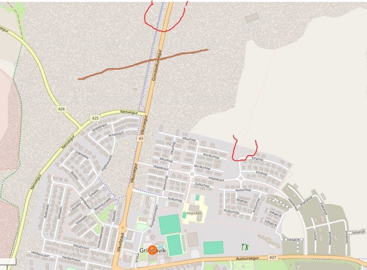
Ook is de opgeworpen wal op het laagste punt,niet hoog genoeg gebleken,zodat ook via die kant de lava nu langzaam richting Grindavik stroomt.
Hieronder een eigen schets bij benadering van de huidige situatie
Rood gekleud zijn beide lavastromen:
Ook zijn ze bezig een nieuwe wal op te werpen,waar de lava eerder op het laagste punt van de 'oude' wal erover ging,dit heb ik met de kleur bruin aangegeven waar het ongeveer is.
Drone compilatie:
| Gewijzigd: 14 januari 2024, 20:40 uur, door pkd19

 Berichtgeving uitbarsting op Reykjanes, IJsland 2023-2024


