Tropsiche storm Michael onderweg naar de VS

Bron afbeelding: NOAA
Michael is op dit moment nog een tropische storm maar kan elk moment geüpgraded worden tot een hurricane. Dit is verrassend omdat de storm zich in een gebied met vrij veel windshear bevindt en windshear niet bevorderlijk is voor de intensificatie van een tropische storm.
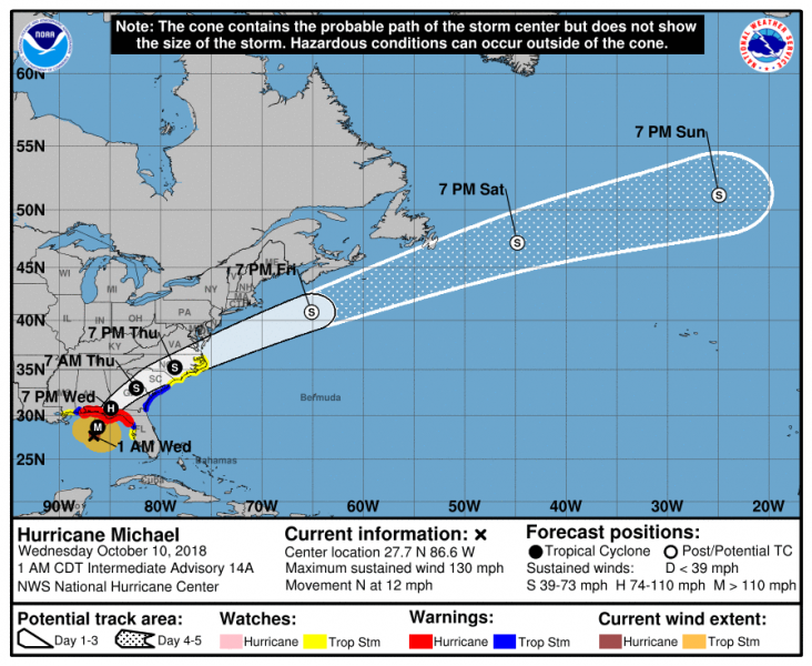
De storm trekt de komende dagen noordoostwaarts richting de VS om komende woensdag landfall te maken in Florida. De storm gaat waarschijnlijk landfall maken rond de stad Tallahassee. De kans dat hurricane Michael een major hurricane (categorie 3 of hoger) is tijdens landfall is realistisch volgens de NHC. Dit omdat de windshear afneemt. Iets om goed te volgen de komende dagen.

Bron afbeelding: NOAA/NHC
| Gewijzigd: 8 oktober 2018, 14:41 uur, door Lako
#Michael continues to hold its own despite the shear which should weaken further. All signs point to more strengthening today.
— Jim Cantore (@JimCantore) 9 oktober 2018
This remains a very dangerous situation for Florida panhandle and big bend residence, and the stronger it gets the longer it takes to wind down inland. pic.twitter.com/3gS1jj5S13
Our office, along with many in the southeast US, began launching extra weather balloons at 1pm today in order to get additional data into the computer models ahead of #HurricaneMichael. These will now be conducted 4 times daily (normally twice daily). #FLwx #ALwx #GAwx #Michael pic.twitter.com/Td2fAgR4n5
— NWS Tallahassee (@NWSTallahassee) 8 oktober 2018
#HurricaneMichael isn't heading to any one town...
— NWS (@NWS) 9 oktober 2018
There are warnings for more than 300 miles of coastline. It's forecast to be a large and dangerous hurricane at landfall.
✔️Life-threatening storm surge
✔️Damaging winds
✔️Life-threatening flash floodinghttps://t.co/VyWINDk3xP pic.twitter.com/nsHYkBjy2r
Massive evacuations continue in #PanamaCityBeach ahead of #michael pic.twitter.com/wEKGGAXsyK
— Jim Cantore (@JimCantore) 8 oktober 2018
Florida Gov. Rick Scott: "You will not survive storm surge." #Michael pic.twitter.com/MqYRP5e0jW
— The Hill (@thehill) 8 oktober 2018
Here’s your evening update on Hurricane #Michael from meteorologist Justin Pullin. pic.twitter.com/d34P9x1nyl
— NWS Tallahassee (@NWSTallahassee) 8 oktober 2018
Tuesday, 4 am ET: Danger of ife-threatening inundation from storm surge during the next 36 hours. #Michael #upwithFOX8 pic.twitter.com/fhM4LevvZ0
— ???? Emily Byrd (@Em_I_Am) 9 oktober 2018
Hurricane Michael is battering Cuba
— Mike Trim WPTV (@MikeTrimWPTV) 9 oktober 2018
- We're showing you #newvideo into our @wptv newsroom right now until 7 this morning
- @glennglazer has the new track & how it affects Florida
#michael #cuba #hurricane #hurricanemichael #weather #severeweather pic.twitter.com/KgknCirzPK
The #HurricaneHunters are currently collecting data inside of Tropical Storm #Michael to try to determine if the storm has become a hurricane. Other data collected will also be used in the models to help fine tune the details of the forecast. #EyeOnTheTropics #Tropics pic.twitter.com/avCYDox1qj
— Grant Gilmore (@grant_gilmore) 8 oktober 2018
Equipment packed and loaded. Teams will head out around 6a for 10-14 day deployment #HurricaneMichael @WTOP pic.twitter.com/aerHkEfIPA
— Melissa Howell (@Mhowell003) 9 oktober 2018
https://sharkysbeach.com/panama-city-beach-webcam-at-sharkys-beachfront-restaurant/
https://sandpiperbeacon.com/panama-city-beach/webcam/fun-cam/
https://www.schooners.com/multimedia/beachcam.htm
https://pwillys.com/beach-cam/
| Gewijzigd: 9 oktober 2018, 11:50 uur, door Joyce.s
In case you’ve ever wondered about some of the takeoff procedures on a WC-130J #HurricaneHunters #HurricaneMichael pic.twitter.com/HS7MjN30tY
— Desirae Duncan WLOX (@DesiraeWLOX) 9 oktober 2018
Flying with the Hurricane Hunters into the eye of Hurricane Michael. The job they do is extremely important to help the National Hurricane Center better predict the intensity of #HurricaneMichael @WLOX pic.twitter.com/8uDQBLAtjV
— Desirae Duncan WLOX (@DesiraeWLOX) 9 oktober 2018
Town of #PinardelRio is a ghost town as #Hurricane #Michael affects western part of #Cuba. Getting reports several towns closer to the southern coast are inaccessible. Storm surge is the big worry! @WPLGLocal10 pic.twitter.com/n0kxriQi8r
— Hatzel Vela (@HatzelVelaWPLG) 9 oktober 2018
Hurricane #Michael is still a Category 1 storm this morning with winds of 90 mph, but landfall is forecast along the Florida panhandle as a major Category 3 hurricane. Damaging winds and dangerous storm surge are expected through the panhandle and big bend region. #FLWX pic.twitter.com/DsI5YrUXxY
— Dani Beckstrom (@danibeckstrom) 9 oktober 2018
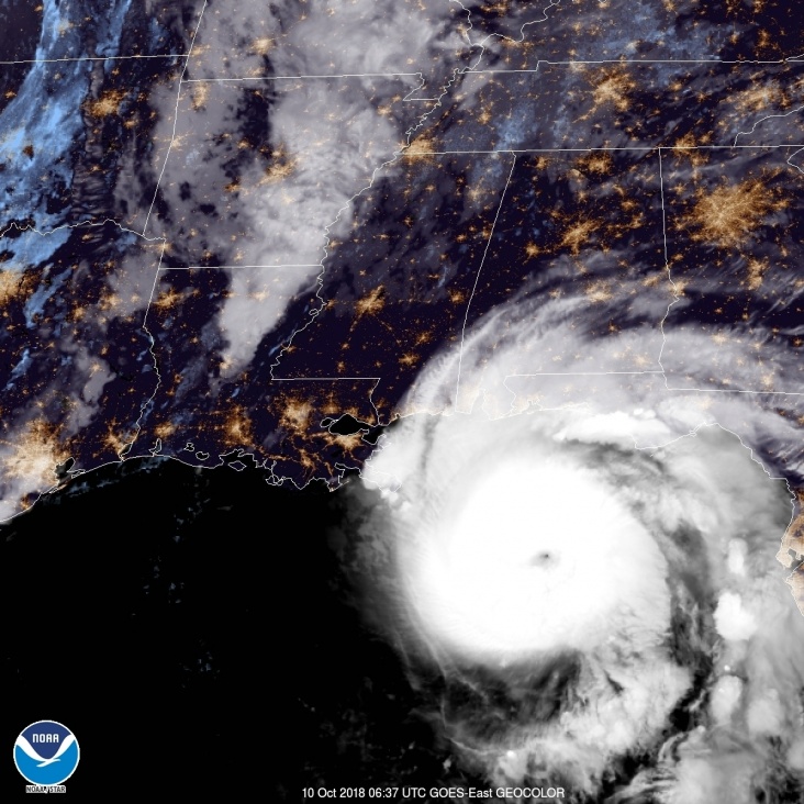
Major hurricane Michael

Bron afbeelding: NOAA
Vandaag komt hurricane Michael aan land in de staat Florida. Landfall van de storm zal waarschijnlijk oost van Panama City plaats vinden. De storm is een uurtje geleden door de NHC geüpgraded naar een categorie 4 hurricane met windsnelheden van boven de 200 km/h. Na landfall neemt de storm snel in kracht af. De wind, hoeveelheid neerslag en het opstuwen van zeewater voor de kust gaan voor veel schade en overlast zorgen.

Bron afbeelding: NOAA/NHC
Na landfall trekt de storm veder in kracht afnemend veder over het zuidoosten van de VS. De storm gaat vervolgens de Atlantische oceaan op waar de storm transformeert tot een extratropical storm en richting Europa trekt.

Bron afbeelding: NOAA/NHC
Storm surge is already creeping over the sea wall and onto the roadways in Cedar Key, FL as seen by this live cam via @hurricanetrack.. Gonna be watching these feeds religiously all day today as #Michael, now a Cat 4 hurricane, moves ashore. #flwx pic.twitter.com/KfB27NSNRe
— Joel Young (@WTVAJoel) 10 oktober 2018
#Michael had 942.4mb in the eye in the last pass. And many places along the coastline are seeing tides a foot or two above normal.
— Kit Cloninger Local4 (@KitCwx) 10 oktober 2018
One thing to remember is were right at a New Moon phase. This will further enhance tide/surge levels... pic.twitter.com/GUmLtJMwy2
Meanwhile... In Florida ????⛈???? #StormChaser #StormLover #HurricaneMichael #BeSafeFlorida @StormHour @RealSaltLife @ThePhotoHour @EarthandClouds @EarthandClouds2 pic.twitter.com/cq5Wx3zUme
— Floridian Creations (@FloridianCreat1) 10 oktober 2018
Getting ready to head back in to #HurricaneMichael on #NOAA42 - what a sobering sight on satellite and radar as the storm approaches the coast pic.twitter.com/4oBo4Dptea
— Andy Hazelton (@AndyHazelton) 10 oktober 2018
The water is starting to rise here at Shell Point Beach, FL. The beach is now covered in water and it’s working it’s way under the house #HurricaneMichael @CBS12 @NWSTallahassee #FLwx pic.twitter.com/qHD9Jisq2Q
— Christopher Hinson (@hinsonphotog) 10 oktober 2018
21k feet above the ground, KEVX radar is measuring 152mph wind. #flwx #HurricaneMichael pic.twitter.com/IJCLOP2Bv6
— Benjamin Jurkovich (@BenjaminJurkovi) 10 oktober 2018
What we are starting to see in the Crystal River area ... remember high tide is not until closer to 5:30 #hurricaneMichael @abcactionnews pic.twitter.com/TIAkrHX2Uh
— Lauren St. Germain (@LaurenWFTS) 10 oktober 2018
Residents in Crystal River, Florida parked their cars up along a bridge because it’s higher ground and their neighborhood is prone to flooding. #HurricaneMichael @WFLA @StormTeam8WFLA pic.twitter.com/C5RHmSggTX
— Omar A. Delgado (@WFLAOmar) 10 oktober 2018
Dodecanese Blvd in Tarpon Springs is closed in the vicinity of the sponge docks due to street flooding. The water is receding but flooding may be an issue again at the next high tide this afternoon as #hurricanemichael passes. @adamzwiner is live this morning. pic.twitter.com/uZRqVQqqon
— Ryan French (@RyanFrenchWFTS) 10 oktober 2018
Rain in Indian shores. Wind also picking up at the edge of a feeder band. #HurricaneMichael pic.twitter.com/pT6B9AU90r
— Roy Kuntz (@RoyKuntz) 10 oktober 2018
Up early again this morning with the AM crew. Starting a long day of #hurricanemichael coverage so stick with me here for updates throughout the day. Water already coming up the road in St Marks. The town was evacuated. @WPTV pic.twitter.com/smNVvPCRbF
— Amy Lipman (@AmyLipman) 10 oktober 2018
FEMA plans to start working around the clock this morning at command center in DeKalb ahead of #HurricaneMichael https://t.co/mEyYqHa3jZ @DarrynMooreWSB has details in a LIVE report at 4:35 a.m. #StormWatchOn2 pic.twitter.com/XvZqRQh4z7
— WSB-TV (@wsbtv) 10 oktober 2018
Hurricane Michael has been upgraded to an "extremely dangerous" category 4 storm, hours before it is due to make landfall in Florida. https://t.co/MxdIA0jyF8
— Alan G (@MoRaY1959) 10 oktober 2018
#Hurricane #Michael #Storm
Preparing for the storm!@USCoastGuard Station #Yankeetown, #Florida, crew members prepare for #HurricaneMichael. The #CoastGuard urges mariners to heed local warnings and prepare early. pic.twitter.com/gf0SDvRp9m
— U.S. Dept of Defense (@DeptofDefense) 9 oktober 2018
Here’s what we are seeing right now. Moved locations a bit - near Cracker’s Bar & Grill. #hurricanemichael #crystalriver #CitrusCounty @abcactionnews pic.twitter.com/SUnZJdcMdv
— Lauren St. Germain (@LaurenWFTS) 10 oktober 2018
#HurricaneMichael: Deputy TJ Indorato walks across the ramp at McRae's in Homosassa. As you can see....the water there is rising. #4am #CCSOPatrol pic.twitter.com/B6wFk0pAF5
— Sheriff Citrus (@SheriffCitrus) 10 oktober 2018
Watch as cars drive through flash flooding in Florida in the build-up to Hurricane Michael.
— AnySource (@SourceAny) 10 oktober 2018
For recent updates on #HurricaneMichael, head here: https://t.co/wjil4RbQq0 pic.twitter.com/nxqrQ9UvuT
FLOOD ALERT: Here's video of Ozello Trail in Crystal river, high tide upon us. @SheriffCitrus deputies are warning residents that the road is not safe to travel at this time. #HurricaneMichael @WFLA DETAILS: https://t.co/s96lHZFxXJ pic.twitter.com/PnWKQDCF4v
— Omar A. Delgado (@WFLAOmar) 10 oktober 2018
#HurricaneMichael still intensifying, and water levels at Apalachicola and Panama City already running 2 feet above average tidal height with the eye still 200 miles offshore. #stormsurge pic.twitter.com/idvgFR4yeZ
— Kevin Kloesel (@texasembassy) 10 oktober 2018
@jaygraymatters @nbcnewschannel live from Panama City Beach, Fl as #HurricaneMichael approaches pic.twitter.com/RlYtat6Vy1
— Craig Helfant (@chelfant) 10 oktober 2018
Some are drinking, some are stacking sandbags. Here's how Florida residents are preparing for #HurricaneMichael as it ramps up to a Category 4 pic.twitter.com/RRNqKfUSDk
— TicToc by Bloomberg (@tictoc) 10 oktober 2018
#PanamaCityBeach looks very deserted as the winds begin to ramp up ahead of #HurricaneMichael pic.twitter.com/OjdR4zdRMY
— Ryan Darr (@_Radarr) 10 oktober 2018
This is the hourly forecast from the National Weather Service for Panama City today. Look at those forecast wind gusts early this afternoon! Awful...just awful. #Michael pic.twitter.com/A75jYZUOGA
— JoeyLive5 (@JoeySovine) 10 oktober 2018
#PanamaCityBeach looks very deserted as the winds begin to ramp up ahead of #HurricaneMichael pic.twitter.com/OjdR4zdRMY
— Ryan Darr (@_Radarr) 10 oktober 2018
Watch @Jeff_Piotrowski's broadcast: Hurricane Michael Update.#flwx #HurricaneMichael https://t.co/qmlEP9vhtm
— Nikki (@NikkiP_420) 10 oktober 2018
NEW: lightning in the early outer bands of CATEGORY 4 Hurricane #Michael from Panama City Beach @breakingweather @accuweather pic.twitter.com/Otjo21T1pn
— Reed Timmer (@ReedTimmerAccu) 10 oktober 2018
Stormchasers die live te volgen zijn: https://severestudios.com/livechase/
Quick update from what we are seeing in Crystal River ... #hurricanemichael #crystalriver #citruscounty @abcactionnews pic.twitter.com/NOoqbi19nu
— Lauren St. Germain (@LaurenWFTS) 10 oktober 2018
Utility trucks and workers are on standby in the event of any power outages from #HurricaneMichael @wjxt4 pic.twitter.com/wzE477FwDJ
— Jennifer Ready (@JenniferReadyTV) 10 oktober 2018
Update: Hurricane #Michael now at 140 mph with more intensification expected before landfall this afternoon! #Tornado threat ramping up with convective outer bands, embedded supercells @breakingweather @accuweather pic.twitter.com/IkgMh7cqaR
— Reed Timmer (@ReedTimmerAccu) 10 oktober 2018
| Gewijzigd: 10 oktober 2018, 12:42 uur, door Joyce.sWind is significant. Current is strong on the Weeki Wachee River in Bayport Park @FOX13News #GoodDayTB #HurricaneMichael #HernandoCounty pic.twitter.com/HuDsJOobla
— Mariah Harrison FOX 13 (@FOX13Mariah) 10 oktober 2018
The @UFWertheim team is working to get the first tower up as the first serious rain bands of #Michael come in. @UMiamiRSMAS pic.twitter.com/ZOq0HpAzDp
— DaveNolan (@DaveNolan305) 10 oktober 2018
Sunshine Skyway Bridge under high wind advisory due to winds from #HurricaneMichael. https://t.co/rg5U1r6zOh pic.twitter.com/bdX0TS6RRJ
— WFLA NEWS (@WFLA) 10 oktober 2018
Live deployment of the Hurricane Eyewall Research Vehicle (HERV) of @MikeTheiss in PCB, FL ahead of powerful Hurricane #Michael. Team coverage at @accuweather as conditions deteriorate @breakingweather pic.twitter.com/rY2q9DKpYR
— Reed Timmer (@ReedTimmerAccu) 10 oktober 2018
Hurricane #Michael churning the #gulf #nature pic.twitter.com/oxGVSzPvgA
— CarmenPineLeaf (@CarmenPineLeaf) 10 oktober 2018
Central pressure is down to 936 MB#Michael pic.twitter.com/4sTQE3iy1l
— NortheastWeatherWx (@NEWeatherWx) 10 oktober 2018
Some pretty rough surf as #HurricaneMichael makes it way towards PCB. @spann @NWSTallahassee @wxnewsdesk @PaulMatadeen pic.twitter.com/VxKtpTPiUB
— CNC Chasing (@PanhandleWX) 10 oktober 2018
Thanks #HurricaneMichael pic.twitter.com/Blay4zuwWh
— dave (@findave3) 10 oktober 2018
#HurricaneMichael is now a Category 4 with 145 mph winds. The storm is expected to hit the Florida Panhandle this afternoon. I’m monitoring beach conditions in Gulf Shores. Look at that sky ???? pic.twitter.com/mEPGIOroKH
— Kendra Turley FOX10 News (@kendraturley) 10 oktober 2018

 Orkaan Michael treft Florida


 | Gewijzigd: 8 oktober 2018, 21:12 uur, door cvandijk


