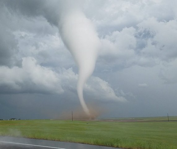
Dangerous storm rattles northern Colorado: Tornadoes touch down in multiple states

Daryl Orr
FORT COLLINS, Colo. — Dangerous weather brewed across northern Colorado, including major cities like Fort Collins and Greeley Monday afternoon through the evening.
A Tornado Watch ran through 8 p.m. for Larimer, Logan, Washington and Morgan Counties. That alert, issued just after 1 p.m., was a precursor to extremely severe weather in the region.
Forecasters and weather experts warned of large hail and tornadoes. Storm chasers caught video and photos of both hail and tornadoes that touched down in the storm's range in both Colorado and Wyoming. Denver7 photojournalist Daryl Orr caught video of two twisters near Cheyenne, Wyoming.
Officials branded the storm a Particularly Dangerous Situation (PDS), a rare alert for a storm in Colorado, and a first for Wyoming.
"We are coordinating a PDS Tornado Watch for portions of Wyoming, Colorado and far west Nebraska," National Weather Service experts said on Twitter. "This is the first PDS watch for Wyoming."
Several strong tornadoes touched down, although it's unclear if any damage has been reported. Hail as large as softballs tumbled from the sky in towns like Pierce and Windsor.
The storm was part of a larger threat for metro areas in Wyoming, including most of the southeastern part of that state. The population inside the entire three-state watch area includes just under a million people, with 364 schools and 20 hospitals.
Bron: http://www.thedenverchannel.com/news/local-news/dangerous-storm-approaches-northern-colorado-tornado-watch-warns-residents-of-threat?page=2
NEW: grapefruit size hail blasting out windshield before supercell dropped a few tornadoes! @breakingweather @SeanSchofer @PrairieChasers pic.twitter.com/sZEupQZmnQ
— Reed Timmer (@ReedTimmerAccu) 13 juni 2017
Incredible day. Dream shot achieved. Still don't believe it all lined up. Nebraska panhandle. pic.twitter.com/4IBiHtvGaS
— Mr Twister (@MrTwisterChaser) 13 juni 2017
Structure in the front, tornado in the back. N of Bushnell #newx 605pm pic.twitter.com/mDvhB7HxKn
— Jacob DeFlitch (@WxDeFlitch) 13 juni 2017
Heres the video I (partial) Shot on Hwy 85 and Rd 22 in Laramie County Wy today. @NWSCheyenne #wywx pic.twitter.com/rvIvXwZBgj
— Daryl Orr (@WxTrackerDaryl) 13 juni 2017
violent #tornado near carpenter Wyoming!!!! pic.twitter.com/9tSeAodclD
— Aaron Rigsby (@AaronRigsbyOSC) 12 juni 2017
Just shot this tornado on Hwy 85 and Rd 22 in Cheyenne @NWSCheyenne @DenverChannel pic.twitter.com/d2wsA36XCi
— Daryl Orr (@WxTrackerDaryl) 12 juni 2017
NEW: large wall cloud with easterly inflow band streaming into it looking south from Wheatland, WY #wywx @NWSCheyenne @breakingweather pic.twitter.com/4Mm2rQTa5t
— Reed Timmer (@ReedTimmerAccu) 12 juni 2017
#Tornado #3, north of Bushnell. A high plains beauty #NEwx pic.twitter.com/jSbqPjFuei
— Michael Charnick (@charnick_wx) 13 juni 2017
Just saw my first tornado in Grover, Colorado! #Tornado #SevereWeather #StormHour #COwx #WYwx #WUTV pic.twitter.com/hG76U7K6RW
— Caleb Westering⛈ (@CalebWestering) 12 juni 2017
Incredible view of the beast #tornado warned supercell near Fort Laramie, Wyoming pic.twitter.com/urmD5sy5kK
— Daniel Shaw (@DanielShawAU) 12 juni 2017
Carpenter hit in tornado outbreak - KGWN https://t.co/DAWeiVhNbw #hng #tornado #earthcentral.org pic.twitter.com/Ww5DKiXyr0
— Faz Fzingo (@Theophany1) 13 juni 2017

 Weer tornado's en flinke hagelstenen in meerdere staten VS


