The short summary is that several supercell storms will develop in WC OK by 5pm. These will all be able to produce tornadoes and will move NE during the late afternoon/evening hours. The threat exists from S KS to N TX and everywhere in between. Just have a plan of action in place should a tornado threaten your area. The storms will move NE out of C OK by 8pm and possibly affect NE OK with flash flooding as they transition away from a tornado threat. Friday more storms with the same outcome will develop in the same areas. We’ll deal with that later.
This map shows extremely unstable CAPE values with 90 degrees of directional shear. This is very favorable for tornadoes.

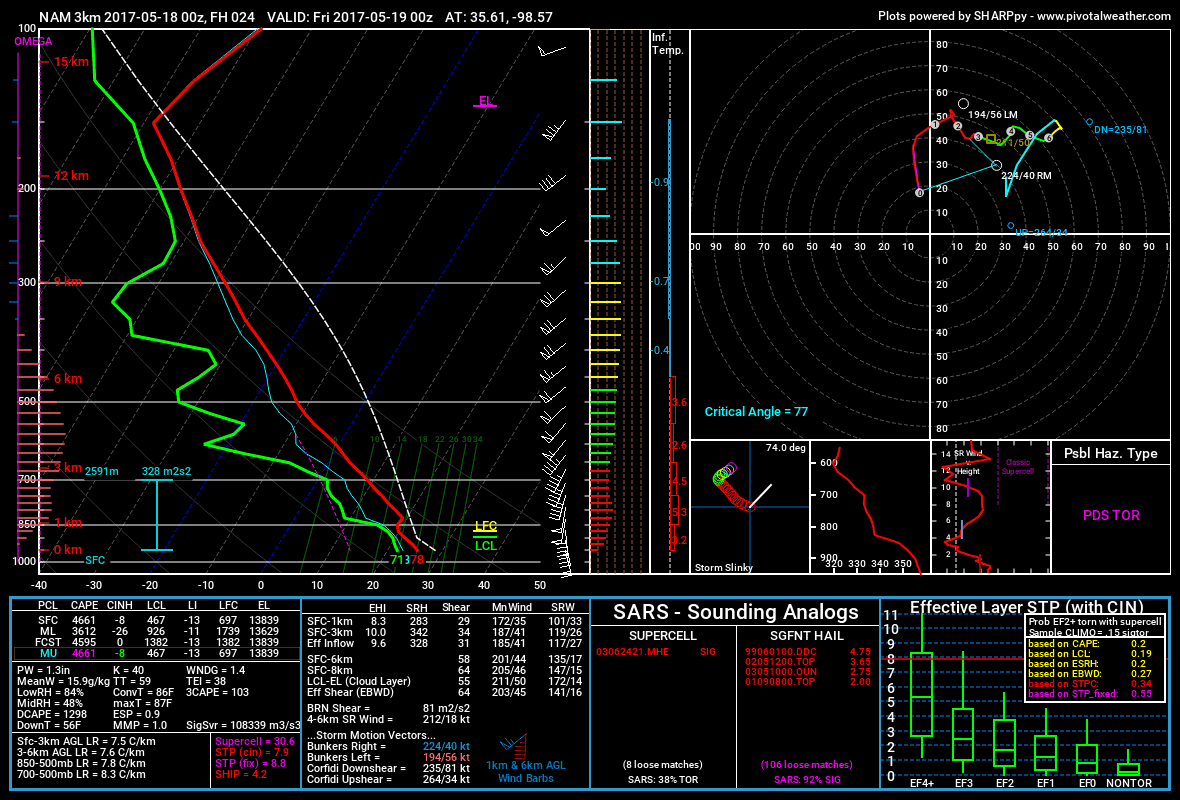
This forecast sounding agrees with the other map and shows a potentially dangerous tornado setup.

bron: http://aarontuttleweather.com/2017/05/17/multiple-tornadoes-expected-thursday-friday/
Wow! Check out this #hail from around the Rome/Lockridge #Iowa area this evening. Photo: Kendra Sparrow Denning pic.twitter.com/THz5fA2BMW
— Iowa Storm Chasing (@IAStormChasing) 18 mei 2017
Strong storms moved through portions of the #Denver metro area this evening littering the ground with #hail. #COwx @WeatherNation pic.twitter.com/0peaTn3efw
— Josh Cozart (@JoshCozartWx) 18 mei 2017
Barn roof into house north of Haverhill, #Iowa. Photo: Matt Stalzer #IAwx pic.twitter.com/jdi3RZICdO
— Iowa Storm Chasing (@IAStormChasing) 18 mei 2017
Target area: STRONG TORNADO potential just east of dry line in western OK or supercells interacting w/ warm front in SW KS Thursday after 4 pic.twitter.com/7Y8JgYxfcK
— Reed Timmer (@ReedTimmerAccu) 18 mei 2017
Een kort verslag van een aantal dagen #tornadojagen in Amerika: https://t.co/KIywKNKPCO pic.twitter.com/x6rD2HBeNI
— Wilfred Janssen (@WilfredJanssen_) 18 mei 2017
Here is a breakdown of our confidence in each specific threat for severe weather for the afternoon and evening. #kswx pic.twitter.com/HzE2AdmwxN
— NWS Dodge City (@NWSDodgeCity) 18 mei 2017
Slowly moistening up the high tornado probability zone: pic.twitter.com/gnNEB1HY9Y
— Jim Cantore (@JimCantore) 18 mei 2017
4:31 PM: #Tornado on storm north of St. John, Kansas. #kswx @NWSDodgeCity @NWSWichita pic.twitter.com/CHvpj83VrZ
— IL Convection Study (@ILConvStudy) 18 mei 2017
#Tornado north of Seiling, OK #ok pic.twitter.com/PHYFlaQRfd
— JR Hehnly (@stormchasing) 18 mei 2017
TORNADO: southwest of Weatherford, OK earlier with street sign ripped from the ground inside rope #tornado! @breakingweather #okwx pic.twitter.com/qOTvWC8Pdd
— Reed Timmer (@ReedTimmerAccu) 19 mei 2017
Amazing #tornado warned storm at 7:25pm near Alva, OK #okwx @spann @USTornadoes pic.twitter.com/6XqpfZaZhG
— Tornado Trackers (@tornadotrackers) 19 mei 2017
Quick clips from this evening near Chester, OK, with @twstdbro #Tornado #bearscage pic.twitter.com/rwl5a3DjzH
— Mike Scantlin (@theScantman) 19 mei 2017
Time-lapse of a rotating supercell thunderstorm in northern Oklahoma today. #okwx pic.twitter.com/XwSL2hbgmi
— Kevin Lighty (@KevinLighty) 19 mei 2017
Starting to go through pictures from today. Saw multiple tornadoes, including large ones. This was the first #tornado we saw. #okwx pic.twitter.com/yiwhjNi20r
— Isaac Polanski (@wxchaser97) 19 mei 2017
Boom!!! Check out this lightning in East Tulsa at 1:25am Friday!! #okwx pic.twitter.com/FFh5QvPUvB
— James Aydelott☂✈ (@jamesaydelott) 19 mei 2017
Three tornado-warned supercells in NW Oklahoma today with a funnel on the first one. A really difficult setup to plan and position. #okwx pic.twitter.com/9EqSROl7hK
— Jeremy Perez (@jperez1690) 19 mei 2017
A few shots from our NW Oklahoma chase on May 18, 2017 #okwx @ryanwunsch pic.twitter.com/j8G47uyV57
— Kyle Brittain (@calgarywxguy) 19 mei 2017

 VS: weer kans op tornado's en grote hagelstenen 18-19 mei


