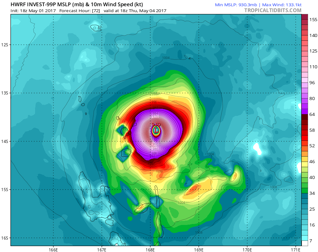
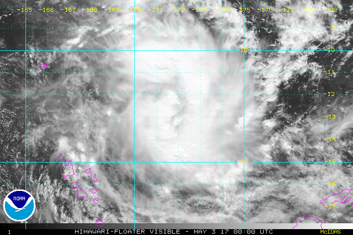
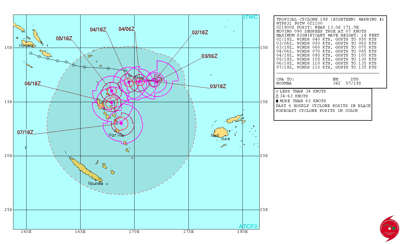
18P is nu cat 2 maar de kracht zal naar alle waarschijnlijkheid nog oplopen tot 3 of 4

Route forecast
Date/Time Category Wind Gust Position
3rd May 2017 06:00 PM Cyclone 2 111 km/h 139 km/h 13° 6.000,171° 54.000
4th May 2017 06:00 AM Cyclone 2 130 km/h 157 km/h 13° 6.000,170° 30.000
4th May 2017 06:00 PM Cyclone 3 157 km/h 194 km/h 13° 12.000,169° 30.000
5th May 2017 06:00 PM Cyclone 4 194 km/h 241 km/h 14° 0.000,167° 54.000
6th May 2017 06:00 PM Cyclone 4 204 km/h 250 km/h 15° 6.000,167° 54.000
7th May 2017 06:00 PM Cyclone 4 204 km/h 250 km/h 17° 0.000,168° 48.000


©The JTWC (Joint Typhoon Warning Center)
Green alert for storm surge impact in Vanuatu
The JRC has developed an experimental global storm surge model, which is run after each advisory issued by the regional tropical cyclone centres. The calculations are published about 20 minutes after a new advisory is detected by GDACS. The calculations identify the populated places affected by storm surge up to three days in advance, using the forecasted track. When forecasts change, the associated storm surge changes too and alert levels may go up or down.This report is for advisory number 1 of tropical cyclone EIGHTEEN-17 issued at 2 May 2017 18:00:00 (GDACS Event ID 1000354).
Summary
Current impact estimate:
Population affected by cyclone-strength winds (>120km/h): 30 thousand
Saffir-Simpson Category: Category 3
Maximum sustained wind speed: 204 km/h
The maximum Storm surge height is 0.3m in Lowitava, Vanuatu. This height is estimated for 06 May 2017 18:00:00.
Evolution
Previous calculations: see calculation for advisory number 1
Storm surge
View animation and affected locations in an interactive map:


Bronnen:
https://higginsstormchasing.com
http://www.gdacs.org/Cyclones/stormsurge.aspx?eventid=1000354&episodeid=1&eventtype=TC
http://webcritech.jrc.ec.europa.eu/ModellingCyclone/cyclonesurgeVM/1000354_JTWC/1/final/P1_MAXHEIGHT_END.jpg
http://webcritech.jrc.ec.europa.eu/ModellingCyclone/cyclonesurgeVM/1000354_JTWC/1/final/outres1.gif
http://hisz.rsoe.hu/alertmap/database/index.php?pageid=event_summary&edis_id=PW-20170503-58069-FJI
| Gewijzigd: 3 mei 2017, 10:06 uur, door Joyce.s
High winds, rough seas, heavy rainfall and flash floods are expected in #Vanuatu tonight with Cyclone Donna. @VanuatuRedCross is prepared. pic.twitter.com/27b14G0ZUD
— Australian Red Cross (@RedCrossAU) 4 mei 2017
5000+ households in the 50km-100km
— IFRC Asia Pacific (@IFRCAsiaPacific) 5 mei 2017
impact zone of #CycloneDonna @FSCCluster @WFPasia pic.twitter.com/sqrr20c6I9
Globe view showing the size of #CycloneDonna.
— Morecast Australia (@Morecast_Au) 5 mei 2017
JMA IR satellite. pic.twitter.com/YqxQcQgkii
#TCDonna #CycloneDonna
— Vanuatu Red Cross (@vanuaturedcross) 5 mei 2017
Vanuatu Red Cross activated it's Emergency Operating Centre (EOC) this morning at its Head Office in Port Vila. pic.twitter.com/WQdkLuIsdu
Reports of damage as #CycloneDonna hits northern #Vanuatu
— Sean Robertson (@Seldomsean63) 5 mei 2017
4:53 pm today
Reports of destruction were beginning to... https://t.co/UTubSZWJtY
Cyclone Donna hits Vanua Lava, turns to southeast; future path & intensity uncertain #Vanuatu #TCDonna #CycloneDonnahttps://t.co/BVV3aOnZJz pic.twitter.com/I2GvGvLbzI
— Vanuatu Digest (@VanuatuDigest) 5 mei 2017
https://t.co/hWRdnIdVZz People shelter in caves as #TropicalCycloneDonna moves slowly across #Vanuatu (pic@vanuaturedcross) pic.twitter.com/5iYsdKN8fc
— RNZ International (@RNZInews) 5 mei 2017
| Gewijzigd: 6 mei 2017, 09:11 uur, door Joyce.sBREAKING: #TCDonna upgraded to a Category 4 cyclone. #RedCross preparing to assist those affected once the weather clears. #cyclonedonna pic.twitter.com/mzPlXhgu34
— corinneambler (@corinneambler) 6 mei 2017
#CycloneDonna intensifies to Cat 5 now moving towards south west of Vanuatu. @WorldVision continues to monitor. @dfat @WorldVisionAus pic.twitter.com/PxzWQYLWNr
— WV Asia-Pacific (@WVAsia) 8 mei 2017
Here's the latest #himawari satellite imagery of #CycloneDonna (Category 5 on the Australian scale) affecting #Vanuatu and #newcaledonia pic.twitter.com/0tb59JaLxO
— Met Office (@metoffice) 8 mei 2017
Tropical #Cyclone Forecast Track Map 47 5:57 pm VUT 8 May 2017 https://t.co/t5Sk55mAFt #TCDonna #Vanuatu #NewCaledonia #CycloneDonna
Le #CycloneDonna se rapproche de la côte Est de la #NouvelleCaledonie.
— Aurely chiron (@kanakwoman) 8 mei 2017
À Poindimié la mer est impressionnante pic.twitter.com/9tCPwXoeLM
Vanuatu Forestry Department office at risk of flooding due to landslide. Repairs & work underway to fix damages & divert water flow #TCDonna pic.twitter.com/HTyznjlKX5
— Glen Reese Pakoa (@GlenPakoa) 8 mei 2017
#TCDonna leaves gardens and homes in #Vanuatu under water as it moves towards #NewCaledonia. Flooding remains a problem for communities. pic.twitter.com/7fH7K5dNJI
— Oxfam in Vanuatu (@OxfamInVanuatu) 8 mei 2017
As some streets in Port Vila continue to #flood in #Vanuatu after #CycloneDonna, World Vision is on the ground to respond as needed. pic.twitter.com/jRdRD6pEWU
— World Vision (@WorldVision) 8 mei 2017
Good news for #Vanuatu as #CycloneDonna weakens and shifts south. All vols are safe, with no major damage reported in most provinces. Hurei! pic.twitter.com/zCxbJH42Kb
— VSA New Zealand (@VSAvolunteer) 8 mei 2017
Aftermath #CycloneDonna
— Méré Vauhi-Leo Tari (@Msovick) 9 mei 2017
School kids in Port Vila, #Vanuatu forced 2 wade across flooded roads#disaster #flooding2017
Credit: Alain Simeon pic.twitter.com/6ek09c8BKI
Jimmy and Netty’s kitchen fell into the river during #TCDonna. @vanuaturedcross is gearing up to help those affected. #cyclonedonna #Vanuatu pic.twitter.com/EkQhGKbWnk
— IFRC Asia Pacific (@IFRCAsiaPacific) 9 mei 2017
VMGD's Lenakel Sea Level station, Tanna, with storm surges from TC Donna 8/5/17 #CycloneDonna #TCDonna #VMGD pic.twitter.com/uCXkH9JDLy
— VMGD (@vmgdVU) 8 mei 2017
#Vanuatu Forestry Dept building at risk of flooding and landslide, Tagabe. #TCDonna #CycloneDonna @WVAsia pic.twitter.com/dzdCFIla5m
— Mike Wolfe (@mikethewolfe) 8 mei 2017

 Cycloon Donna is nu Categorie 5


