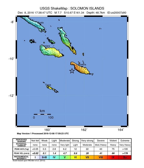
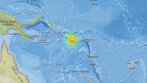
ORIGIN TIME - 0739 AM HST 08 DEC 2016
COORDINATES - 10.7 SOUTH 161.4 EAST
LOCATION - SOLOMON ISLANDS
MAGNITUDE - 8.0 MOMENT
A TSUNAMI WATCH IS ISSUED FOR THE STATE OF HAWAII
Bron: http://ptwc.weather.gov/
Edit: USGS spreekt van magnitude 7,7.

Bron: USGS | Gewijzigd: 8 december 2016, 19:21 uur, door Sven
Tsunamiwaarschuwing na zware aardbeving Salomonseilanden
Na een zware aardbeving met een magnitude van 7,7 bij de Salomonseilanden is een tsunamiwaarschuwing afgegeven voor de eilanden en de kusten van Vanuatu, Papoea-Nieuw-Guinea, Nauru, Nieuw-Caledonië, Tuvalu en Kosrae.
Dat melden het aardbevingsinstituut USGS en Pacifische instituut voor tsunamiwaarschuwingen.
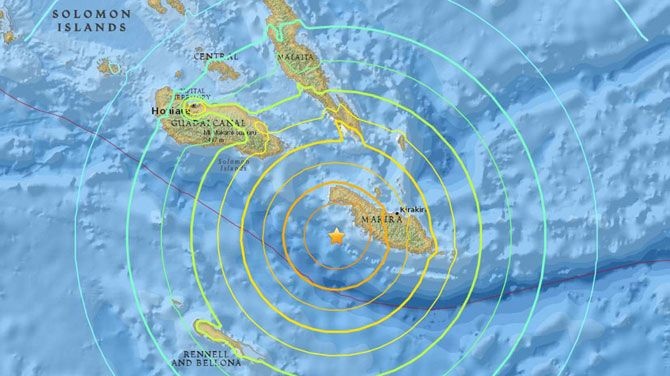
De aardbeving had donderdagochtend (lokale tijd) plaats. De tsunami kan de komende drie uur aan land komen. De aardbeving vond plaats op 48,7 kilometer diepte en was 68 kilometer van de kust van het zuidoostelijke eiland Makira.
Er vinden vaker zware aardbevingen plaats bij de Salomonseilanden. De eilanden maken deel uit van de Ring van Vuur, een zone van tektonische activiteit in de Grote Oceaan waardoor er veel aardbevingen en vulkaanuitbarstingen zijn.
Bron: nu.nl | Gewijzigd: 31 januari 2017, 11:02 uur, door Joyce.s
Tsunamigevaar na zware aardbeving op Salomonseilanden

Ter hoogte van de Salomonseilanden heeft zich vandaag een krachtige aardbeving voorgedaan. De schok had een magnitude van 7,7. Dat heeft het Amerikaans Geofysisch Instituut USGS gemeld. Er wordt ook gewaarschuwd voor een tsunami.
De beving deed zich voor om 18.38 uur Belgische tijd en had een magnitude van 7,7. Het epicentrum bevond zich op 49 km diepte, 68 km ten westzuidwesten van Kirakira.
Tsunamigevaar
Het Pacific Tsunami Warning Center waarschuwt voor een "heel grote en gevaarlijke tsunami". De overheden van de getroffen eilanden worden aangemaand maatregelen te nemen en de bevolking in de kustgebieden te waarschuwen.
"Er zijn de komende drie uren gevaarlijke tsunamigolven mogelijk aan sommige kusten van de Solomoneilanden", klinkt het. "Vanuatu, Papua Nieuw Guinea, Nauru, Nieuw Caledonië, Tuvalu en Kosrae lopen gevaar."
Ring of Fire
De Salomonseilanden bestaan uit Papua Nieuw Guinea, Nauru en Vanuatu en liggen in de zogenoemde 'Ring of Fire'. De 'Ring van Vuur' is een gebied in de Stille Oceaan dat regelmatig getroffen wordt door aardbevingen. Ook vulkaanuitbarstingen zijn er schering en inslag.
Bron: hln.be | Gewijzigd: 8 december 2016, 19:33 uur, door Sven
Aardbeving in Stille Oceaan, tsunami-alarm afgekondigd

De Salomonseilanden in de Stille Oceaan zijn getroffen door een aardbeving met 7.7 magnitude. Er is een tsunami-alarm afgekondigd.
De aardbeving deed zich voor op een diepte van 50 kilometer. Het epicentrum lag voor de kust van het eiland Makira.
Tsunamigolven zijn mogelijk binnen de drie uur na de beving en kunnen de kusten van de Salomonseilanden, Vanuatu, Papoea Nieuw-Guinea, Nauru, Nieuw-Caledonië, Tuvalu en Kosrae treffen, waarschuwt het Pacific Tsunami Warning Center.
De Salomonseilanden zijn een eilandengroep in het westelijke deel van de Stille Oceaan. Ze bestaan uit zes grote en bijna duizend kleine eilandjes ten oosten van Nieuw-Guinea. Er wonen zo'n 600.000 mensen op de archipel.
Bron: deredactie.be
Update 19u54
Het Pacific Tsunami Warning Center heeft ondertussen enkele update geplaatst::
EARTHQUAKE MAGNITUDE DOWN GRADED TO 7.8 FROM 8.0.
BASED ON ALL AVAILABLE DATA THERE IS NO TSUNAMI THREAT TO THE STATE OF HAWAII. THEREFORE... THE TSUNAMI WATCH FOR HAWAII IS NOW CANCELLED.
- TSUNAMI WAVES REACHING 1 TO 3 METERS ABOVE THE TIDE LEVEL ARE POSSIBLE ALONG SOME COASTS OF SOLOMON ISLANDS.
- TSUNAMI WAVES REACHING 0.3 TO 1 METERS ABOVE THE TIDE LEVEL ARE POSSIBLE FOR SOME COASTS OF PAPUA NEW GUINEA... AND VANUATU.
- TSUNAMI WAVES ARE FORECAST TO BE LESS THAN 0.3 METERS ABOVE THE TIDE LEVEL FOR THE COASTS OF AMERICAN SAMOA... AUSTRALIA... CHUUK... FIJI... GUAM... HOWLAND AND BAKER... INDONESIA... KERMADEC ISLANDS... KIRIBATI... KOSRAE... MARSHALL ISLANDS... NAURU... NEW CALEDONIA... NEW ZEALAND... NORTHERN MARIANAS... POHNPEI... SAMOA... TOKELAU... TONGA... TUVALU... AND WALLIS AND FUTUNA.
Update 20u14
- TSUNAMI WAVES REACHING 1 TO 3 METERS ABOVE THE TIDE LEVEL ARE POSSIBLE ALONG SOME COASTS OF SOLOMON ISLANDS.
- TSUNAMI WAVES REACHING 0.3 TO 1 METERS ABOVE THE TIDE LEVEL ARE POSSIBLE FOR SOME COASTS OF PAPUA NEW GUINEA.
- TSUNAMI WAVES ARE FORECAST TO BE LESS THAN 0.3 METERS ABOVE THE TIDE LEVEL FOR THE COASTS OF FRENCH POLYNESIA.
Residents take to the hills as powerful quake hits Solomon Islands
Residents of the remote Solomon Islands rushed into the hills after a powerful 7.8 earthquake struck early on Friday, with some reports of small tsunami waves as aftershocks rattled the South Pacific nation.Authorities in the Solomons, where several significant naval battles were fought during World War Two, did not find any evidence of casualties or widespread damage by sundown, although communication can be difficult across the archipelago of some 900 far-flung islands.
The huge underwater quake triggered a tsunami warning for a wide swath of the South Pacific. While that warning was later canceled by the Pacific Tsunami Warning Center (PTWC), the threat of aftershocks and unusual waves, abnormal high tides and currents meant many villagers near the epicenter were preparing to spend the night in the relative safety of the hills.
Life appeared to be back to normal for most people on the Solomons' six main islands within hours of the quake, although residents in southern Makira province closest to the epicenter remained cautious. The province on San Cristobal island, about 200 km (120 miles) east of the capital, Honiara, was still being rattled by aftershocks more than 12 hours after the first quake.
"We are quite safe up the hill from the sea," John Pirimare, a resident on Nafinua Island, told Reuters by telephone from the hills to where he and up to 600 other villagers had evacuated immediately after the quake.
Constable Abel Muri from the Kirakira police station in Makira said there were no reported casualties.
"Some people are beginning to come back in to town, but others have stayed at the higher ground," Muri told Reuters.
"We are now just experiencing the smaller earthquakes."
The U.S. Geological Survey originally recorded the pre-dawn quake with a magnitude of 8.0 but later downgraded it to 7.8.
There was a modest rise in the sea level in the region, with a 43 cm (17 inches) lift recorded in neighboring New Caledonia, south of the epicenter, according to the Hawaii-based PTWC.
While the PTWC canceled its warning of a potentially hazardous tsunami for the Solomons and neighboring island chains, authorities in New Caledonia ordered people on the east coast and in the Loyalty islands to move to higher ground.
Martin Karani, a politician who represents Makira in the Solomons parliament, said the southern parts of the province were the most affected.
"Waves have come in to the villages and taken away the dugout canoes that were on the shore and also some houses that were down near the beach, but when it came through all of the villagers had already taken off," he told Reuters.
He said he had heard on short-wave radio, the only means of contacting the remote, worst-hit areas, that around 25 houses were washed away on the western side of the island.
The Solomons, perched on the geologically active "Pacific Ring of Fire", were hit by a devastating tsunami following an 8.1 magnitude quake in 2007. That disaster killed at least 50 people, left dozens missing and destroyed 13 villages.
Lyndene Wan from the charity group Plan International Australia said residents in the capital were largely unruffled.
"Things definitely shook for some minutes, but I’m walking around, I’ve been up the hill, and looking out over Honiara there is no visible damage here," Wan said.
(Additional reporting by Jane Wardell, Byron Kaye, Swati Pandey; Writing by Jonathan Barrett; Editing by Lincoln Feast Paul Tait)
Bron: http://www.reuters.com/article/us-quake-solomon-idUSKBN13X26P

 Aardbeving kracht 7,8 Solomon Eilanden


