DAWN COMET HAS TWO TAILS:
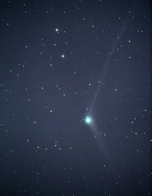
Now that the morning Moon is waning in brightness, amateur astronomers are once again getting a good view of Comet Catalina. Images reveal not one, but two tails. Randy Carter sends this picture from Elkin, North Carolina, taken Dec. 4th:
"This is a 420 second exposure through my 6-inch Celestron telescope," says Carter. "I estimate the magnitude of the comet to be approximately +7."
That means Comet Catalina is too dim to see with the unaided eye, but an easy target for backyard telescopes as it glides through the constellation Virgo in the predawn sky not far from the planet Venus. Sky maps and observing tips may be found in this article from Sky and Telescope.
Why does Comet Catalina have two tails? Almost all comets do. The sun-warmed nucleus of a comet spews a mixture of dust and gas into space. Quickly, the mixture separates into two distinct tails: The gaseous "ion tail" is pushed straight away from the sun by solar wind. The weightier dust tail resists solar wind pressure and aligns itself more or less with the comet's orbit. In Carter's picture of Comet Catalina, the ion tail points up; the dust tail points down.
This is Comet Catalina's first visit to the inner solar system--and its last. The comet's close encounter with the sun in mid-November has placed it on a slingshot trajectory toward interstellar space. It will become easier to see in the weeks ahead as it recedes from the sun, possibly brightening to 5th or 6th magnitude. A date of special interest is Dec. 7th when the comet pairs up with the planet Venus and the waning crescent Moon in the early morning sky. Catalina will be about 4o degrees away from the Venus-Moon combo. Stay tuned for more information about that, and meanwhile browse the realtime comet gallery for more sightings
Bron:http://www.spaceweather.com/
MAGNETIC STORM ON COMET CATALINA:
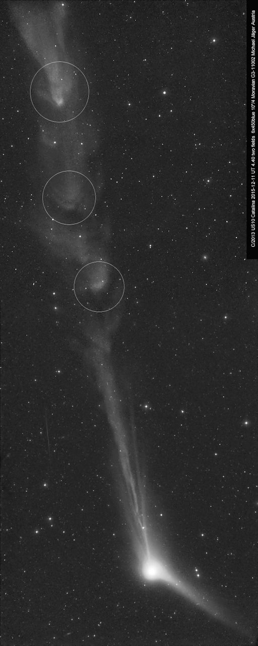
Earth isn't the only place with geomagnetic storms. Comets can have them, too. Such a storm appears to be in progress right now in the sinuous ion tail of Comet Catalina (C/2013 US10). Note the blobs of plasma circled in this Dec. 11th photo taken by Michael Jäger of Jauerling, Austria:
These blobs are a sign of stormy space weather. Observers of comets frequently witness plasma blobs and 'disconnection events' in response to CMEs and gusts of solar wind. In extreme cases, a comet's tail can be completely torn off.
The underlying physics is akin to terrestrial geomagnetic storms. When magnetic fields around a comet bump into oppositely-directed magnetic fields in a CME, those fields can link together or "reconnect." The resulting burst of magnetic energy can make waves, blobs, or even ruptures in the comet's tail. When CMEs hit Earth, a similar process takes place in the planet's magnetosphere powering, among other things, the aurora borealis.
Comet Catalina is brightening in the eastern pre-dawn sky, not yet visible to the naked eye, but an easy target for backyard telescopes. Detailed finder charts may be found in this article from Sky & Telescope. Monitoring is encouraged!
Bron:http://www.spaceweather.com/

 Komeet Catalina heeft niet 1 maar 2 staarten


