Deze foto is niet meer beschikbaar Deze foto is niet meer beschikbaar
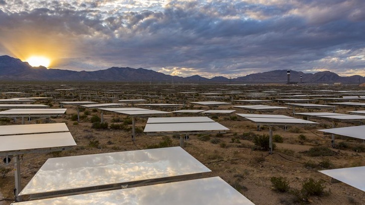
Links: Ivanpah, the world's largest solar thermal power plant, has 300,000 panels and went operational in February. (BrightSource Energy)
Rechts: NASA's Landsat 8 took this image of the plant in the Mojave Desert on Dec. 25, 2013. The plant has three towers, each with a surrounding array, indicated here by the arrow. (Jesse Allen and Robert Simmon,NASA Earth Observatory/U.S. Geological Survey)
Deze foto is niet meer beschikbaar Deze foto is niet meer beschikbaar
L: MetLife Stadium in East Rutherford, N.J., is shown prior to the start of Super Bowl XLVIII between the Denver Broncos and the Seattle Seahawks. (Jeff Zelevansky/Getty Images)
R: NASA's Earth Observing-1 satellite caught this image of the stadium, part of the Meadowlands Sports Complex, on Jan. 30, 2014.
Deze foto is niet meer beschikbaar Deze foto is niet meer beschikbaar
L: The world’s largest offshore wind farm, known as the London Array, sits in the Thames Estuary about 12 miles off England’s eastern coast. The array has 175 turbines spread out over 40 square miles. (London Array Limited)
R: The straight grid of the turbines is clear in this NASA Landsat image taken on April 28, 213, 20 days after the wind farm became fully functional. (NASA/USGS/Jesse Allen/Robert Simmon)
Deze foto is niet meer beschikbaar Deze foto is niet meer beschikbaar
L: Bushfires raged in Australia during September and October of 2013. Here, a fire on a hillside threatens suburbs in Sydney on Sept. 10. (Brett Hemmings/Getty Images)
R: When NASA’s Aqua satellite took this image on Oct. 17, 90 wildfires were burning across Australia. (NASA/Jeff Schmaltz/LANCE/EOSDIS MODIS Rapid Repsonse Team)
Deze foto is niet meer beschikbaar Deze foto is niet meer beschikbaar
L: Japan’s most active volcano, Sakura-jima, erupts hundreds of times every year. (Wikimedia Commons/Tanaka Juuyoh)
R: NASA’s Landsat 8 took this true-color image of an ash plume from Sakura-jima trailing over Japan’s Kyushu island on Nov. 23, 2013. (NASA/USGS/Jesse Allen/Robert Simmon)
Deze foto is niet meer beschikbaar Deze foto is niet meer beschikbaar
L: Every second, more than 500,000 gallons of water rush over the edge of the Canadian portion of Niagara Falls, one of the largest waterfalls on the planet. (Janine Curry/Flickr)
R: Commercial Earth observation satellite IKONOS took this shot of the falls on Aug. 2, 2004. (Space Imaging)
Deze foto is niet meer beschikbaar Deze foto is niet meer beschikbaar
L: A tornado ripped through Moore, Okla., on May 20, 2013, killing 24 and leaving a path of destruction felt for months. (Wikimedia Commons/Ks0stm)
R: The tornado was spawned from a supercell thunderstorm, caught here in natural color by NASA’s Aqua satellite at 2:40 p.m. on May 20, 16 minutes before the twister first touched down. (NASA/Jeff Schmaltz, LANCE MODIS Rapid Response
Deze foto is niet meer beschikbaar Deze foto is niet meer beschikbaar
l: A man walks away from the shoreline as Super Typhoon Haiyan smashes into coastal communities on the central island of Cebu on November 8, 2013. (STR/AFP/Getty Images)
r: NASA’s Aqua satellite took this natural-color image of the typhoon as it approached the Philippines on Nov. 7, 2013. (NASA/LANCE/EOSDID MODIS Rapid Response Team)
Deze foto is niet meer beschikbaar Deze foto is niet meer beschikbaar
l: A rare meteorological event called a temperature inversion filled the Grand Canyon with fog between Nov. 29 and Dec. 2, 2013. (Grand Canyon National Park)
R: An instrument called MODIS — Moderate Resolution Imaging Spectroradiometer — on NASA’s Terra satellite caught this view of the fog on Nov. 30, 2013. (NASA/Jeff Schmaltz/LANCE/EOSDIS MODIS Rapid Response Team)
Deze foto is niet meer beschikbaar Deze foto is niet meer beschikbaar
L: About 50,000 years ago, a 300,000-ton meteorite slammed into the middle of what is now the Arizona desert, leaving behind a crater almost a mile wide and 590 feet deep, colloquially known as Meteor Crater. (Wikimedia Commons/Stan Shebs)
R:This 3-D view of the crater was made using a false-color image from NASA’s Terra satellite and data from the U.S. Geological Survey. (NASA/GSFC/MITI/ERSDAC/JAROS, and U.S./Japan ASTER Science Team)
Deze foto is niet meer beschikbaar Deze foto is niet meer beschikbaar
L: The diverse ecosystems of coral reef support about one-third of global marine fish species, in addition to being some of the most beautiful attractions for divers worldwide. (Wikimedia Commons/Toby Hudson)
R: A NASA satellite called Landsat 8 took this image on April 20, 2013, of Australia’s Princess Charlotte Bay, part of the Great Barrier Reef World Heritage Site. (NASA/USGS/Jesse Allen/Robert Simmon)
Deze foto is niet meer beschikbaar Deze foto is niet meer beschikbaar
L: Aircraft are barely visible through thick smog on the tarmac of Hongqiao Airport in Shanghai as severe pollution blankets the city on Dec. 6, 2013. (Peter Parks/AFP/Getty Images)
R± The gray areas in this Dec. 7, 2013, photo from NASA’s Terra satellite show pollution as it stretched 750 miles from Beijing to Shanghai. (NASA/Jeff Schmaltz, LANCE MODIS Rapid Response)
Bron± Weather.com

 Aarde vs Ruimte: één object, twee foto's uit twee gezichtspunten

 Deze foto is niet meer beschikbaar
 Deze foto is niet meer beschikbaar
 Deze foto is niet meer beschikbaar
 Deze foto is niet meer beschikbaar
 Deze foto is niet meer beschikbaar
 Deze foto is niet meer beschikbaar
 Deze foto is niet meer beschikbaar
 Deze foto is niet meer beschikbaar
 Deze foto is niet meer beschikbaar
 Deze foto is niet meer beschikbaar
 Deze foto is niet meer beschikbaar
 Deze foto is niet meer beschikbaar


