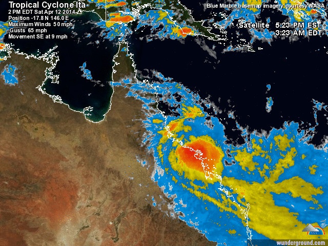
.Centre located near...... 16.5 degrees South 145.4 degrees East
.Location accuracy........ within 35 kilometres
.Recent movement.......... towards the south southeast at 10 kilometres per hour
.Wind gusts near centre... 120 kilometres per hour
.Severity category........ 1
.Central pressure......... 990 hectoPascals

TROPICAL CYCLONE ADVICE NUMBER 49
Issued at 4:21 pm EST on Saturday 12 April 2014
A Cyclone WARNING is now current for coastal areas from Cape Tribulation to Proserpine.
The Cyclone WARNING between Cooktown and Cape Tribulation has been cancelled.
At 4:00 pm EST Tropical Cyclone Ita, Category 1, was estimated to be 8 kilometres west southwest of Port Douglas and 60 kilometres northwest of Cairns, and moving south southeast at 10 kilometres per hour.
Tropical Cyclone Ita is forecast to move to the southeast during the next 24 hours, most likely close to or just offshore of the southern tropical and central coast, and is now expected to maintain tropical cyclone intensity.
DAMAGING winds with gusts to 120 kilometres per hour are likely between Port Douglas and Cairns this afternoon and evening, extending to Innisfail overnight. GALES with wind gusts to 100 kilometres per hour may extend further down the coast to Townsville during Sunday if the system moves offshore.
As the cyclone tracks near the coast, a storm tide is expected between Cape Tribulation and Cairns. Large waves may produce minor flooding along the foreshore. People living in areas likely to be affected by this flooding should take measures to protect their property as much as possible and be prepared to help their neighbours.
Heavy rainfall, that may lead to flash flooding, is currently occurring about the east tropical coast and ranges between about Port Douglas and Ayr, and should extend south to about Yeppoon during Sunday. Isolated 24 hour totals in excess of 300mm are likely.
Tropical Cyclone Ita should move further southeast into the Coral Sea and away from the Queensland coast during Monday and Tuesday. Rainfall will decrease about the North Tropical Coast during Sunday and Monday as the system moves away.
Bron: BOM | Gewijzigd: 12 april 2014, 08:50 uur, door Marga
Cycloon Ita, die gisteren aan land kwam in het noordoosten van Australië, heeft geen slachtoffers gemaakt en weinig schade aangericht. Er zijn wel wat daken beschadigd en bomen omgewaaid, aldus Australische media.
Ook zijn op verschillende plaatsen stroomleidingen beschadigd. Daardoor viel voor duizenden burgers de stroom uit. De hevige regenval leidde tot overstromingen, die noopten tot het afsluiten van enkele wegen.
Bron: AD
Last Updated: zaterdag 12 april 2014, 20:00:00 0
Wind: 85 KPH
Location: -17.8N 214E
Movement: SE at 9 mph


 Berichtgeving TC Ita (West Pacific)


