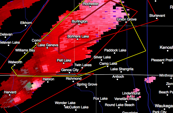
9:34 a.m. CST Sunday: Thunderstorm capable of producing a tornado is tracking toward Harvard and Richmond, Ill., which are located to the northwest of Chicago
9:50 a.m. CST Sunday: NWS trained spotter reported a funnel cloud three miles west of Hebron, Ill.
9:57 a.m. CST Sunday: Radar-indicated tornado is currently located near Pell Lake, Wis., and heading toward the Wisconsin communities of Bohners Lake and Union Grove.
10:16 a.m. CST Sunday: Another thunderstorm capable of producing a tornado is tracking toward Hebron and Richmond, Ill.
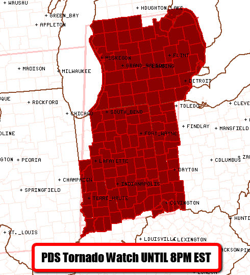
TORNADO WATCH NUMBER 562
NWS STORM PREDICTION CENTER NORMAN OK
1120 AM EST SUN NOV 17 2013
THE NWS STORM PREDICTION CENTER HAS ISSUED A
* TORNADO WATCH FOR PORTIONS OF
INDIANA
FAR NORTHERN KENTUCKY
LOWER MICHIGAN
WESTERN OHIO
LAKE HURON
LAKE MICHIGAN
...THIS IS A PARTICULARLY DANGEROUS SITUATION...
* PRIMARY THREATS INCLUDE...
SEVERAL INTENSE TORNADOES LIKELY
NUMEROUS DAMAGING WIND GUSTS LIKELY WITH SEVERAL SIGNIFICANT
GUSTS TO 80 MPH POSSIBLE
SEVERAL LARGE HAIL EVENTS TO 1.5 INCHES IN DIAMETER LIKELY
THE TORNADO WATCH AREA IS APPROXIMATELY ALONG AND 90 STATUTE
MILES EAST AND WEST OF A LINE FROM 40 MILES SOUTHEAST OF
BLOOMINGTON INDIANA TO 55 MILES NORTHWEST OF SAGINAW MICHIGAN.
FOR A COMPLETE DEPICTION OF THE WATCH SEE THE ASSOCIATED WATCH
OUTLINE UPDATE (WOUS64 KWNS WOU2)
Bron: SPC
10:20 a.m. CST Sunday: New tornado watch box has been issued for Indiana, southern Michigan and western Ohio. This watch box is in effect until 7 p.m. CST Sunday and includes Indianapolis and Detroit
10:22 a.m. CST Sunday: Thunderstorms with a history of producing hail are tracking toward areas just to the northwest of Peoria, Ill.
10:30 a.m. CST Sunday: Thunderstorm capable of producing a tornado is located near Wind Lake, Wis., and headed toward Milwaukee.
10:33 a.m. CST Sunday: "There are no plans to delay [the Bears-Ravens game]," stated the Chicago Bears on their official twitter page. Severe weather still expected to reach Chicago around the start of the game.
10:42 a.m. CST Sunday: Thunderstorm capable of producing a tornado is located near Ashland, Ill., and tracking toward Athens and Greenview, Ill. The thunderstorm is expected to cross I-55, north of Springfield.
Big #tornado on the ground near Roanoke, IL. The blue on the bottom right is radar picking up tornado debris
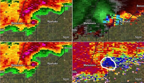
Erik Willey @erikwill
Debris ball signature on storm east of Peoria. Large #tornado on the ground reported

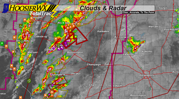
HoosierWX.com @HoosierWX
Tornado on the Ground in Central IL. Tracking to the NNE. Be weather ready!!!
 | Gewijzigd: 17 november 2013, 18:23 uur, door Marga
11:03 a.m. CST Sunday: NWS spotter heard from an emergency manager of a brief tornado touchdown near the intersection of Routes 29 and 98, south of Peoria, Ill. The damage is being reported near Peoria.
11:04 a.m. CST Sunday: "Confirmed damaging tornado in central Illinois," was reported on the National Weather Service's Office in central Illinois
11:15 a.m. CST Sunday: The tornado tracking northeastward away from Peoria, Ill., has been described as "large" by emergency manager. The tornado is tracking toward the Illinois communities of Metamora, Roanoke and Minonk.
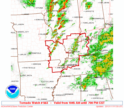
TORNADO WATCH NUMBER 563
NWS STORM PREDICTION CENTER NORMAN OK
1045 AM CST SUN NOV 17 2013
THE NWS STORM PREDICTION CENTER HAS ISSUED A
* TORNADO WATCH FOR PORTIONS OF
NORTHEAST ARKANSAS
SOUTHERN ILLINOIS
FAR SOUTHWEST INDIANA
WESTERN KENTUCKY
SOUTHEAST MISSOURI
NORTHWEST TENNESSEE
* EFFECTIVE THIS SUNDAY MORNING AND EVENING FROM 1045 AM UNTIL
700 PM CST.
* PRIMARY THREATS INCLUDE...
SEVERAL TORNADOES WITH A FEW INTENSE TORNADOES POSSIBLE
SEVERAL LARGE HAIL EVENTS WITH A FEW VERY LARGE HAIL EVENTS TO 2
INCHES IN DIAMETER POSSIBLE
SEVERAL DAMAGING WIND GUSTS TO 70 MPH POSSIBLE
THE TORNADO WATCH AREA IS APPROXIMATELY ALONG AND 90 STATUTE
MILES EAST AND WEST OF A LINE FROM 30 MILES NORTH OF CARBONDALE
ILLINOIS TO 20 MILES WEST SOUTHWEST OF DYERSBURG TENNESSEE. FOR
A COMPLETE DEPICTION OF THE WATCH SEE THE ASSOCIATED WATCH
OUTLINE UPDATE (WOUS64 KWNS WOU3).

Ari Sarsalari @AriWeather
Likely tornado damage from about 11am CDT in Pekin, IL RT @f8andbthere2: #peoria. Tornado hits Pekin

Sean Breslin @Sean_Breslin
Peoria, Illinois >> RT @Alexandra_WMBD: Horrific damage | Gewijzigd: 14 februari 2017, 15:28 uur, door Joyce.s

Ed Quinn @CataulaGaWX
#FB RT @mattdanielwx: RT @gensiniwx Initial stage of tornado. Taken near East Peoria

SevereStudios @severestudios
RT @foreverchasin: Adam Lucio saw this tornado near Roanoke Illinois
| Gewijzigd: 17 november 2013, 18:34 uur, door Marga
Update: "Numerous homes damaged" in Washington, IL due to a #tornado at 11:05a CST. That tornado is near Dana, IL as of 11:38am.
Jacob Wycoff @4cast4you
11:38am CT: A confirmed tornado was located near Rutland and Dana, IL moving NE at 55mph.
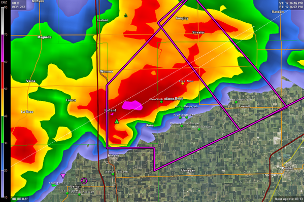
Developing: Emergency management reports significant tornado damage in East Peoria, IL to homes with trees/power lines downed (11 am CST)
Liveblog accuweather:
11:17 a.m. CST Sunday: A confirmed large and extremely dangerous tornado was located near Roanoke, Ill., and racing to the northeast. The tornado will threaten the communities of Minonk and Streator.
11:30 a.m. CST Sunday: Severe weather, including potential tornado, is on track to reach Chicago's lakefront in 45 to 60 minutes.
11:32 a.m. CST Sunday: Emergency manager reports a downed cell phone tower by a tornado two miles east of Metamora, Ill.
11:34 a.m. CST Sunday: AccuWeather.com Senior Meteorologist Frank Strait reports seeing indicators of debris on radar in Roanoke County, Ill. | Gewijzigd: 17 november 2013, 18:45 uur, door Marga

 Extreem weer USA 17 november 2013





 | Gewijzigd: 17 november 2013, 19:00 uur, door Marga


