Volgens knmi e.d komen de buien pas in de middag met kans op zware windstoten, hagel en onweer.
Is dit dan gewoon een voorproefje, en komt de rest vanmiddag?
Als iemand het antwoord weet, dank je alvast. .
Ja ik vraag het me ook af
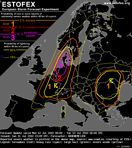
Kleine opsomming. Onweer waargenomen, KNMI oranje, Estofex Level 2, Shelfs waargenomen, VID adviseerd mensen niet meer de weg op te gaan enz enz.
Dit word gewoon een heerlijke dag.......of toch eentje om je zorgen over te gaan maken :P
Hier nu bewolkt 24 graden en vies warm.

Valid: Mon 12 Jul 2010 08:00 to Tue 13 Jul 2010 06:00 UTC
Issued: Sun 11 Jul 2010 23:09
Forecaster: GROENEMEIJER
A level 3 for severe wind gusts, tornadoes, large hail and excessive precipitation was issued for eastern Netherlands, northwestern and northern Germany, and southwestern Denmark.
A level 2 was issued for an area surrounding the level 2 area fro the same weather phenomena.
A level 1 was issued for severe wind gusts, large hail, and excessive precipitation surrounding the level 2 area, including SWern Sweden, SE Norway, much of Germany, the western Alps, northern Italy and northern, central and eastern France.
A level 1 was issued for the central and eastern Balkans and western parts of the Ukraine mainly for excessive precipitation.
SYNOPSIS
Please refer to the original Storm Forecast for a general discussion of the weather pattern.
DISCUSSION
Benelux, northwestern and northern Germany, western Denmark...
A strong bowing MCS has formed over central France overnight.This system is expected to move quickly NNEward. As the boundary layer warms ahead of this system, the chances of strong and extreme wind gusts will increase. Per 00 and 06 UTC soundings about 1500-2500 J/kg MLCAPE should become available i this air-mass.
Moreover, a few elevated supercells have formed over the Benelux. As forcing by the upper trough increases, coverage of these storms will also increase. With strong helicity being in place and LCL heights being low, storms that become surface-based will have a risk of tornadoes, that may be strong. The threat will be highest roughly in a 100 km broad zone to the northwest of a line from Maastricht to Dortmund to Kiel, where surface winds are from the ENE and boundary layer temperatures moderate.
Both for the disctinct risk of extreme wind gusts with the bow echo, and for the risk of tornadoes an upgrade to level 3 was decided. Moreover, extreme precipitation and large hail will be possible.
It is expected that the bow echo will move into Denmark during the second half of the afternoon and during the evening. Probably the threat of extreme wind gusts will persist at least until the mid-evening, when the system moves into an area of less instability.
dat ik dat nog mag meemaken alleen is het niet bij mij
MEGA MEGA MEGA MEGA MEGA, ik ga de schuilkelder in, zit net in level 3!!!!!!!!!!!!!!!!!!!!!!!!!!!!
Benelux, northwestern and northern Germany, western Denmark...
A strong bowing MCS has formed over central France overnight.This system is expected to move quickly NNEward. As the boundary layer warms ahead of this system, the chances of strong and extreme wind gusts will increase. Per 00 and 06 UTC soundings about 1500-2500 J/kg MLCAPE should become available i this air-mass.
Moreover, a few elevated supercells have formed over the Benelux. As forcing by the upper trough increases, coverage of these storms will also increase. With strong helicity being in place and LCL heights being low, storms that become surface-based will have a risk of tornadoes, that may be strong. The threat will be highest roughly in a 100 km broad zone to the northwest of a line from Maastricht to Dortmund to Kiel, where surface winds are from the ENE and boundary layer temperatures moderate.
Both for the disctinct risk of extreme wind gusts with the bow echo, and for the risk of tornadoes an upgrade to level 3 was decided. Moreover, extreme precipitation and large hail will be possible.
It is expected that the bow echo will move into Denmark during the second half of the afternoon and during the evening. Probably the threat of extreme wind gusts will persist at least until the mid-evening, when the system moves into an area of less instability.
aldus: Estofex

 Onweerskansen 11 en 12 juli


