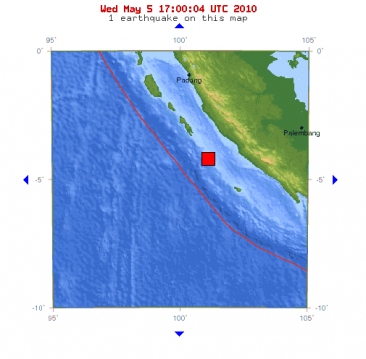
A magnitude 6.3 earthquake struck off the coast of Sumatra in Indonesia on Wednesday, the U.S. Geological Survey said. The quake, which was earlier reported to be of 6.6. magnitude, occurred at 11:29 p.m. local time (1629 GMT) and was centered about 137 km (85 miles) southwest of Bengkulu in Sumatra, the USGS said. The depth was 18 km (11 miles). There were no immediate reports of damage or injuries.
The Pacific Tsunami Warning Center said there was no threat of a destructive, widespread tsunami although there was a small possibility of a local tsunami near the area of the quake.
Bron: Reuters
Deze foto is niet meer beschikbaar
Magnitude 6.3
Date-Time
* Wednesday, May 05, 2010 at 16:29:02 UTC
* Wednesday, May 05, 2010 at 11:29:02 PM at epicenter
Location 4.081°S, 101.069°E
Depth 18.1 km (11.2 miles) (poorly constrained)
Region SOUTHERN SUMATRA, INDONESIA
Distances
135 km (85 miles) WSW of Bengkulu, Sumatra, Indonesia
215 km (135 miles) WSW of Lubuklinggau, Sumatra, Indonesia
355 km (220 miles) SSE of Padang, Sumatra, Indonesia
680 km (420 miles) WNW of JAKARTA, Java, Indonesia
Deze foto is niet meer beschikbaar Deze foto is niet meer beschikbaar
Onweersdagen: 0

 Sumatra getroffen door krachtige aardbeving


 Deze foto is niet meer beschikbaar


