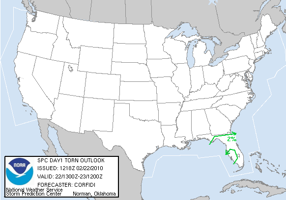
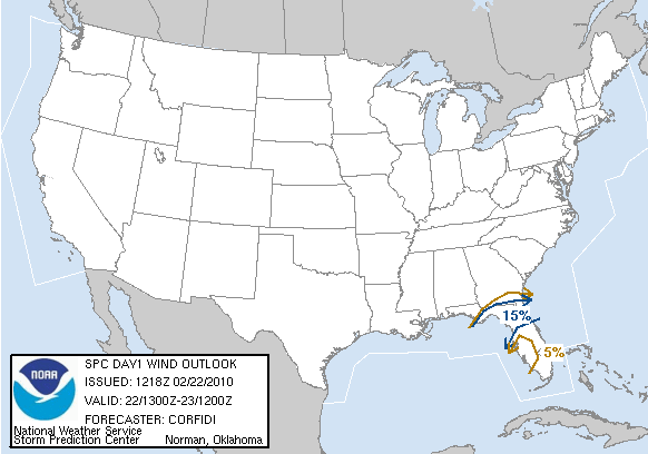
Wederom zijn er vandaag weer kansen op 'severe thunderstorms' in Florida. Bijbehorend bij een lagedrukgebied trekt er vandaag een storing over Florida. Op deze storing ontstaan onweersbuienen in het midden en zuiden van Florida kunnen 'severe thunderstorms' ontstaan. Tijdens deze buien kunnen zware windstoten voorkomen en er is weer een hele kleine kans op tornado's.
Ten noorden van het lagedrukgebied wordt ook sneeuw verwacht, hieronder een kaartje met de hoeveelheden.
Sneeuw:


Kans op tornado's:

Kans op zware windstoten:

...There is a slgt risk of svr tstms today across central and s
FL...
...central/s fl today...
A strong srn stream shortwave trough will move ewd from the ne gulf
coast across central/n fl today to off the se atlantic coast
tonight. An initial surface cyclone in the fl panhandle will weaken
by midday as a new cyclone begins to form just off the ne fl/se
ga/sc coasts. This latter cyclone will then move newd just offshore
from the carolinas and deepen quickly through early wednesday. S of
the cyclone...A cold front will move across fl during the
day...clearing the se fl coast this evening.
A band of strong low-mid level ascent precedes the midlevel
trough...as evidenced by the persistent band of rain and embedded
thunderstorms from central fl to se ga. The instability feed
sustaining this convection is off the surface from the sw
/originating over the se gulf of mexico/. Surface-based instability
has been slow to materialize across much of the fl peninsula as a
result of lingering continental polar air and short modification
times in the wake of a prior frontal intrusion in the past two days.
The band of strongest ascent will move off the ne fl coast early
this morning...across central fl by late morning...and the srn
remnants of the band will cross s fl this afternoon.
Meanwhile...the belt of strongest low-level shear and most favorable
hodograph structures for rotating storms will shift quickly e of the
peninsula by midday as cyclogenesis proceeds off the atlantic coast.
This will leave largely unidirectional wind profiles with strong
low-mid level speed shear and weak instability in its wake.
Isolated damaging gusts will be possible with the stronger storms
within the convective band this morning across central fl and early
this afternoon into s fl...but the overall severe threat is on the
margins of what justifies a slight risk as a result of weak
instability. A low probability threat for strong winds will also
continue into this afternoon across central/n fl with low-topped
convection in an environment of steeper low-level lapse rates and
weak instability accompanying the surface cold front.
...central/nrn ca and wrn nv through tonight...
An initial weakening shortwave trough will eject newd over
central/nrn ca and nw nv today...while a stronger upstream low
approaches nrn ca early wednesday. steep lapse rates/weak
instability will support a threat for isolated thunderstorms today
in the nrn san joaquin/sacramento valleys...and e of the sierra
nevada range into wrn nv late this afternoon/evening.
Bron: spc.noaa.gov/Accuweather | Gewijzigd: 2 maart 2010, 16:57 uur, door Sietse

| Gewijzigd: 2 maart 2010, 17:05 uur, door Sietse

 [USA] Onweersverwachting 2 maart 2010


