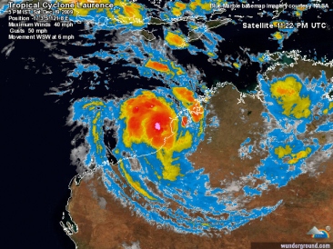
De tropische cycloon Laurence zet met een snelheid van 230 kilometer per uur koers naar de kust van Kimberly in West-Australië. Het is de eerste cycloon van het seizoen die de Australische deelstaat bedreigd. Bewoners van de kust hebben de raad gekregen om zich voor te bereiden op de cycloon.

De tropische storm bevindt zich momenteel op 55 kilometer ten noorden van Kuri Bay en 155 kilometer ten noordoosten van Cockatoo Island. Verwacht wordt dat ze vandaag het eiland en de Koolaneilanden bereikt met windstoten van honderd kilometer per uur. De hevige wind zal volgens de laatste voorspellingen ook gepaard gaan met stevige buien.
De bewoners van de eilanden hebben de raad gekregen om zich voor te bereiden op de storm. De plaatselijke luchthaven wordt alvast gesloten en de aboriginalgemeenschap in Oombulgurri sluit ook haar deuren. Laurence onstond zondag boven de Timorzee en is in kracht toegenomen van categorie één naar categorie vier.
©Hln
Tropical Cyclone Laurence is expected to develop into a severe cyclone over the next 24 hours. People in Western Australia's north are being warned to prepare for the cyclone as it moves within 100 kilometres of Broome.

A cyclone warning has been issued for coastal areas from Cape Leveque to Pardoo including Broome. The cyclone is a category 2 system and Joe Courtney from the weather bureau's cyclone warning centre says it will gain strength as it moves across the ocean.
"There is a real risk of a major impact, more likely on Monday when it will move south towards the east Pilbara coast," he said. "We are expecting this system to develop into an intense system, maybe a category 4 system by late tonight." Cyclone Laurence has already brought heavy rains and destructive winds to communities and cattle stations across the north Kimberley.
©ABC News
TROPICAL cyclone Laurence has weakened as it tracks towards central Australia but residents are still being warned to expect flooding from heavy rain into this morning. The Bureau of Meteorology (BoM) says gusts of up to 100km/h from the downgraded category two cyclone could reach the Northern Territory and South Australian borders today. Heavy rain lashed the Pilbara region in northwest WA last night, with the Fire and Emergency Services Authority of Western Australia (FESA) warning of flash flooding.
"Very heavy rainfall has been reported in the Yarrie Station area and upstream due to Cyclone Laurence," FESA said last night. "Heavy rainfall has continued in the catchment and more is expected overnight above Warrawagine Station, including the Oakover River catchment." Around 150mm of rain was expected to fall on the east Pilbara region, the BoM said.
© DailyTelegraph..com.au
Cyclone Laurence in north-west Western Australia is expected to be downgraded to a tropical low by this afternoon. Meteorologists say the cyclone, which is about 500 kilometres north-west of Giles in the Pilbara region, has been downgraded from a category 3 to a category 1 system overnight.
Residents in Warburton and Giles should expect squally winds and heavy rains as the cyclone moves towards them this afternoon. Those in the Pilbara region are no longer on red alert. Emergency crews say they will spend the morning assessing the situation in the most recent town to be hit, Cotton Creek. However, they are not expecting any major damage.
The cyclone is expected to cross the Western Australia border this evening and could have an impact on communities in the Northern Territory.
©Abc.net

 Tropische cycloon Laurence stormt af op West-Australië


