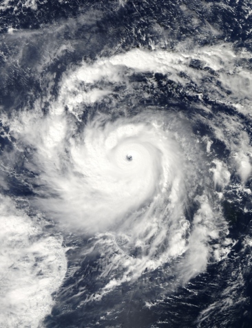
© Onweer-Online, Satelliet: ©NASA
Guam's holding out for a break this Thanksgiving as Typhoon Nida tracks North-Northwest and is expected to remain West of the Marianas. According to the National Weather Service, at 3:50 p.m. Chamorro Standard Time, the well-defined 20-mile-diamater eye of Typhoon Nida, with 100 percent eye wall coverage was located by radar near 11.6 degrees North Latitude and 143 degrees East Longitude. This is about 180 miles southwest of the Guam WSR-88D radar at an elevation of 24,000 feet. The storm-turned-typhoon has continued to edge closer to Guam since yesterday and has picked up speed, albeit slowly.
NWS reported at 2:00 p.m. that Nida is moving North-Northwest at around 12 MPH. Little change in motion was expected during the next 24 hours. Typhoon force winds extended outward up to 40 miles from the center and Tropical Storm force winds extended outward up to 100 miles from the center. Fortunately for Guam and the Northern Marianas, as Nida moves North, she also drifts west.
© Guam News Factor
Nida is still holding on to Super Typhoon status in the Western Pacific Ocean, and over the weekend, is forecast to pass east of both Iwo To and Chichi Jima islands. Although the center of Nida will remain at sea, both islands will face heavy surf, gusty winds and heavy rainfall.

On Friday, November 27, at 0900 UTC (4 a.m. ET or 6 p.m. local Asia/Toyko time) Nida had maximum sustained winds near 149 mph (130 knots) with gusts to 184 mph (160 knots)! That makes Nida a Category 4 Typhoon. The range of sustained winds for a Category 4 typhoon (or hurricane) range from 131 to 155 mph (114-135 knots or 210-249 kilometers/hour).The National Hurricane Center says of a Category 4 Typhoon/hurricane: "Extremely dangerous winds causing devastating damage are expected."
Nida is about 300 miles in diameter, so tropical storm force winds extend as far as 150 miles from the center of the storm. Typhoon/hurricane-force winds extend 70 miles from Nida's center. Nida's eye is estimated to be about 25 nautical miles in diameter. Nida's center was located 415 nautical miles northwest of Guam, near 17.8 degrees North latitude and 139.2 degrees East longitude. Nida was moving north near 10 mph.
Nida was generating dangerously high waves, up to 39 feet high. As its center sweeps past Iwo To and Chichi Jima this weekend, those islands can expect very high surf with dangerous battering waves.
Nida is moving north, but will start heading northeast in the next day or two. It will also transition into an extra-tropical storm and continue weakening on its northern journey into cooler waters and areas of stronger wind shear.
©NASA/Goddard Space Flight Center

 Berichtgeving over (super)typhoon Nida


