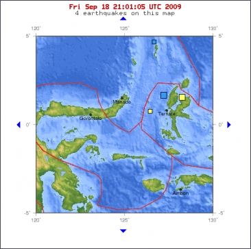
An earthquake with magnitude of 5.8 on the Richter scale jolted eastern parts of Indonesia on Saturday morning, Meteorology and Geophysics Agency said here.
The quake struck at 01:34 a.m. Jakarta time (1834 GMT Friday) with epicenter at 117 kms northwest Ternate of North Maluku province and at 91 kms under sea bed, an official of the agency Beni Hermanto told Xinhua.
The intensity of the quake was felt at 2 to 3 MMI (Modified Mercally Intensity) at Manado, the capital of North Sulawesi province, he said.
Indonesia, homed by over 230 million people, sits on a vulnerable quake-hit zone so called "the Pacific Ring of Fire," where two continental plates, stretching from Western hemisphere to Japan, meet, which causes frequent seismic and volcanic movements.
©Xinhuanet

Magnitude 5.8
Date-Time
* Friday, September 18, 2009 at 18:34:22 UTC
* Saturday, September 19, 2009 at 03:34:22 AM at epicenter
Location 1.757°N, 127.191°E
Depth 92.7 km (57.6 miles) set by location program
Region HALMAHERA, INDONESIA
Distances 110 km (65 miles) NNW of Ternate, Moluccas, Indonesia
260 km (165 miles) E of Manado, Sulawesi, Indonesia
1575 km (980 miles) SSE of MANILA, Philippines
2430 km (1510 miles) ENE of JAKARTA, Java, Indonesia


 Stevige aardbeving in oosten Indonesië


