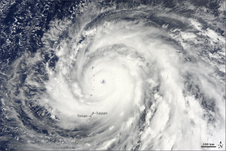
Super Typhoon Choi-wan had just become a monstrous Category 4 super typhoon on the morning of September 15, 2009, when the Moderate Resolution Imaging Spectroradiometer (MODIS) on NASA’s Terra satellite captured this photo-like image. Choi-wan is a perfect circle with bands of clouds pin-wheeling around the dense center. The dark blue surface of the Pacific Ocean is visible through the clear eye, which is defined by a towering wall of clouds.

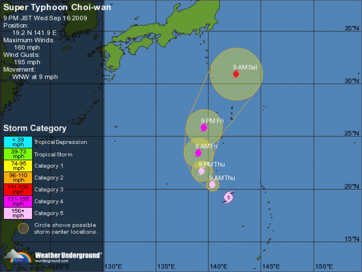
At the time the image was taken, Choi-wan had sustained winds estimated at 230 kilometers per hour (145 miles per hour or 125 knots), according to the Joint Typhoon Warning Center. Choi-wan was strengthening. Twenty-four hours later, the storm reached Category 5 status with sustained winds of 260 km/hr (160 mph or 140 knots). The Joint Typhoon Warning Center expected the storm to intensify a little more.
While the storm raked across the Northern Mariana Islands and was targeting the small islands of Iwo To and Chinchi Jima, it was not forecast to hit any major land mass. In this image, Super Typhoon Choi-wan is centered over the northern arc of the Mariana Islands in the western Pacific Ocean, with the larger islands of Guam, Saipan, and Tinian located on the southern edge of the storm. The islands north of Saipan are volcanic and are either unoccupied or sparsely populated.
The large image provided above is at MODIS’ maximum resolution of 250 meters per pixel. The MODIS Rapid Response System provides the image in additional resolutions.
©

Typhoon Choi-Wan strengthened to a Category 5 storm over the Pacific to the south of Japan, according to the U.S. Navy Joint Typhoon Warning center.

Choi-Wan’s eye was about 619 kilometers (385 miles) south of the Japanese Island Iwo To, formerly known as Iwo Jima, at 10 p.m. Tokyo time today. Its maximum sustained winds increased to 260 kilometers per hour from 241 kph yesterday as it moved northwest at 17 kph.
The storm, the strongest of this year’s northwest Pacific season, is expected to maintain its strength through tomorrow before weakening slightly by 3 a.m. on Sept. 18, the center said. Category 5 is the strongest on the five-step Saffir- Simpson scale and is assigned to storms with winds of 250 kph or higher.
Choi-Wan is more than 2,000 kilometers across with a clearly defined eye, as seen in a NASA satellite photograph. It’s expected to approach islands to the south of Tokyo tomorrow and its eye is forecast to pass within about 500 kilometers of Tokyo on Sept. 19, according to the center.
Waves at the center are 12 meters (39 feet) high and winds are gusting to 315 kph.
The Japan Meteorological Agency, which is also monitoring the storm, calls it an “extremely strong†typhoon.
>Lees hier verder<
©Bloomberg.com
vroeg ik me al een tijdje af
groeten riesz
Orkaan is de naam die meestal wordt gebruikt voor tropische stormen in het Atlantische gebied en in de kuststreken bij Mexico. Tyfoon is de meest gebruikte term op de Stille Oceaan. De laatste zijn vaak echte regenmonsters.
Tropische cyclonen. Zo heten ze officieel in Nederland. Orkanen , zo worden ze vaak genoemd, maar eigenlijk is de term orkaan bedoeld voor windkracht 12, en dit hoeft niet per se met een tropische cycloon samen te gaan, sommige sterke stormdepressies hebben ook buiten de tropen (extratropical cyclones, de depressies) winden bij zich van windkracht 12.
Nu ligt het eraan waar een tropische cycloon zich bevindt hoe het systeem genoemd wordt. Rond de VS worden ze hurricanes genoemd. In Azie worden ze Typhoons genoemd, zoals Talkyr al zei. Rond Australie Cylones, al wordt door Amerikanen voor de cyclones rond Australie ook de term Willy-Willys gebruikt, echter de Australiers zelf refereren met de term Willy-Willys naar dustdevils, stofhozen. | Gewijzigd: 17 september 2009, 00:55 uur, door stratocumulus

 Supertyfoon Choi-wan


