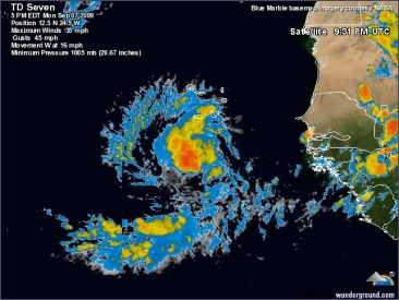
A new tropical depression has formed in the far eastern Atlantic Ocean and is expected to strengthen into a tropical storm later on Monday or Tuesday, the U.S. National Hurricane Center said. At 5 p.m. (2100 GMT), the depression was located about 160 miles south of the southernmost Cape Verde islands and its maximum sustained winds were near 35 mph, the center said. Strengthening is forecast over the next couple of days ... and the depression is expected to become a tropical storm tonight or Tuesday, it said in a advisory.
Deze foto is niet meer beschikbaar
It would be named Fred, the sixth named storm of the 2009 Atlantic hurricane season. But NHC forecasters said weather conditions over the Atlantic were expected to allow the cyclone to turn northwestward in a couple of days, followed by a turn to the north hereafter. This suggested it might not threaten land on its immediate track, but tropical weather systems are notoriously unpredictable.
Energy traders keep a close eye on storms that could enter the Gulf of Mexico and disrupt offshore U.S. oil and natural gas production or refinery operations along the coast. Also, commodities traders watch storms that could damage agriculture crops such as citrus and cotton in Florida and other states along the coast to Texas.
Pricing of insurance-linked securities, which transfer insurance risks associated with natural disasters to capital markets investors and can be used to hedge other weather risk exposures, can also be affected by the path of a storm.
©Reuters
Tropical Storm Fred formed in the eastern Atlantic Ocean on Monday with top winds of 40 mph, but did not immediately threaten any land, the U.S. National Hurricane Center said. Fred was the sixth named tropical storm of the 2009 Atlantic-Caribbean hurricane season that runs from June through November. Forecasters said some strengthening was expected in the next couple of days. Tropical storms become hurricanes when their top sustained winds reach 74 mph.
At 11 p.m. (0300 GMT on Tuesday), Fred was centered about 245 miles south-southwest of the southernmost Cape Verde Islands and was moving west at 15 mph. A slight gradual turn to the west-northwest and northwest was forecast over the next two days, the center said. "Some additional strengthening is forecast during the next couple of days," it said.
Fred's anticipated immediate track would keep it far from the Gulf of Mexico, where U.S. oil and gas operations are clustered.Energy traders keep a close eye on storms that could enter the Gulf of Mexico and disrupt offshore U.S. oil and natural gas production or refinery operations along the coast. Also, commodities traders watch storms that could damage agriculture crops such as citrus and cotton in Florida and other states along the coast to Texas. Pricing of insurance-linked securities, which transfer insurance risks associated with natural disasters to capital markets investors and can be used to hedge other weather risk exposures, can also be affected by the path of a storm.
Bron: Reuters
| Gewijzigd: 8 september 2009, 08:59 uur, door Marga

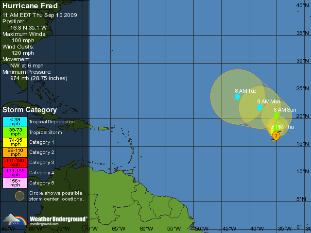
De boven de Atlantische Oceaan ontwikkelde tropische storm Fred is een orkaan geworden. Vanochtend bevond Fred zich op ongeveer 715 km ten zuidwesten van Kaap Verdië, om aan 19 km per uur een noordwestelijke koers aan te houden. Het natuurgeweld is nu een orkaan van categorie 1.
Het orkaanseizoen in het Atlantisch gebied startte op 1 juni en duurt tot 30 november. Voorlopig is 2009 het kalmste seizoen sinds tien jaar. Meteorologen schrijven dit toe aan het klimaatfenomeen El Nino boven de Stille Oceaan.
©Hln
en als dat dan het geval zal zijn dan zal de wind in de hoge luchtlagen misschien een westen wind erbij brengen
dan trekt hij dus naar het n-o en dus misschien wordt dit dan wel een echte najaars storm en/of kanaalrat
ik weet niet of dit ook in de mogelijk heid is maar volgens mij wel
(altijd positief hé)
http://www.weer.nl/nl/home/weer/tropische_...m/2009-al7.html
bron mijzelf en deze bovenstaande pagina | Gewijzigd: 10 september 2009, 19:23 uur, door onweerlwd@hotmail.com
en als dat dan het geval zal zijn dan zal de wind in de hoge luchtlagen misschien een westen wind erbij brengen
dan trekt hij dus naar het n-o en dus misschien wordt dit dan wel een echte najaars storm en/of kanaalrat
ik weet niet of dit ook in de mogelijk heid is maar volgens mij wel
(altijd positief hé)
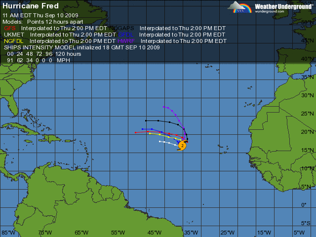
Nou zet dat maar lekker uit je hoofd. De laatste berekeningen gaan er van uit dat Fred richting de oostkust van Amerika gaat en dat hij in vijf dagen tijd afgezwakt is tot een tropische depressie


Hurricane Fred weakened to a tropical storm in the eastern Atlantic on Friday and forecasters expected it to fade in the coming days. Fred's maximum sustained winds fell to 70 mph, meaning it was no longer a hurricane. The storm has been deteriorating gradually since Thursday due to high wind shear a difference in wind speeds at different altitudes that sapped its strength, the U.S. National Hurricane Center said. Weakening is forecast and Fred will gradually fade, the Miami-based center said.
Fred, the sixth storm of the 2009 Atlantic hurricane season, was thousands of miles (km) east of the populous U.S. East Coast and the storm-vulnerable oil and gas fields of the Gulf of Mexico, and was expected to die by Tuesday without affecting land. Fred, which was meandering slowly north, peaked on Wednesday when its top winds reached 120 mph, making it a "major" Category 3 storm on the five-step Saffir-Simpson intensity scale. It was the second major hurricane of the Atlantic season.
Elsewhere, the Miami-based National Hurricane Center said a low pressure system near the Texas Coast had a low chance less than 30 percent of becoming a tropical cyclone during the next 48 hours. The energy market was watching the low because it formed in the oil-rich Gulf of Mexico.
©Reuters

 Berichtgeving over de orkaan Fred


