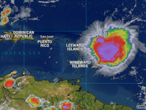
Tropical Storm Erika strengthened late Tuesday after forming hours earlier in the Atlantic, the National Hurricane Center said. As of 11 p.m. ET, Erika was centered about 365 miles (585 km) east of the northern Leeward Islands, the hurricane center said. Its maximum sustained winds were near 60 mph (95 km/hr), with higher gusts.

While Erika meandered Tuesday evening, it was expected to start moving west-northwest at about 9 mph overnight. Some strengthening is possible during the next 24 hours, forecasters said. Erika has been meandering for the past few hours, but it should begin to move toward the west-northwest near 8 mph (13 km/hr) on Wednesday. Tropical-storm force winds extended outward up to 120 miles (195 km) from Erika's center.
The storm was moving west-northwest at near 8 mph (13 km/hr), and was expected to continue doing so for the next couple of days, the hurricane center said. Tracking maps put the storm east of the Bahamas by Sunday. Tropical storm watches were in place for the Caribbean islands of St. Maarten, Antigua, Barbuda, St. Kitts, Nevis, Anguilla, St. Martin and St. Barthelemy, according to the hurricane center. A tropical storm watch means that tropical storm conditions, including winds of at least 39 mph, are possible within 36 hours.
The northern Leeward Islands, the U.S. and British Virgin Islands and Puerto Rico have been advised to monitor Erika's progress.
©CNN
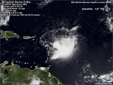
Tropical Storm Erika, which formed late Tuesday in the western Atlantic Ocean, weakened slightly early Wednesday as it approached the northern Leeward Islands, the U.S. National Hurricane Center said in its last advisory. At about 8 a.m. EDT (1200 GMT), the disorganized center of Erika was located about 160 miles east-southeast of the Leeward Islands, moving west at 7 miles per hour with maximum sustained winds down slightly to about 45 mph.
Deze foto is niet meer beschikbaar
Tropical storm warnings have been issued for Antigua, Barbuda, Montserrat, St. Kitts, Nevis, Anguilla, St. Martin, Saba and St. Eustatius. Erika, the fifth named storm of the Atlantic hurricane season, was expected to turn west-northwest with slightly increased forward speed over the next day or two, and some strengthening was possible on Thursday.
NHC projected wind speed to increase to as much as 60 to 65 mph over the next two days before dropping back to about 55 mph by the weekend. Most computer models show the system taking a northwesterly track toward Florida or the Southeast U.S. coast, but some models show it steering a more westerly course toward Puerto Rico, the Dominican Republic and Cuba.
©Reuters
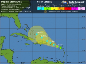
Tropical Storm Erika in the northeast Caribbean Sea was expected to gradually weaken over the next couple of days as it tracked toward Puerto Rico and then the Dominican Republic, the U.S. National Hurricane Center said early Thursday. In its 2 a.m. EDT (0600 GMT) advisory, NHC said the poorly organized center of Erika was located about 260 miles east-southeast of San Juan, Puerto Rico, moving west-northwest at 7 miles per hour with maximum sustained winds holding at about 40 mph.
Deze foto is niet meer beschikbaar
Some increase in forward speed was expected over the next day or two. The system was expected to approach the U.S. and British Virgin Islands and Puerto Rico later today. Tropical storm warnings remain in effect for Dominica, Guadeloupe, Antigua, Barbuda, Montserrat, St. Kitts, Nevis, Anguilla, St. Martin, Saba and St. Eustatius. A tropical storm warning means that tropical storm conditions can be expected within 24 hours. Tropical storm watches remain in effect for the U.S. and British Virgin Islands and Puerto Rico.
©Reuters
De tropische storm Erika raast vandaag over de Bovenwindse eilanden Sint Maarten, Sint Eustatius en Saba. Rond 04.00 uur lokale tijd is Erika de drie Antilliaanse eilanden vanuit het oosten genaderd en zal zich in de loop van de dag noordwestwaarts richting Puerto Rico bewegen. Erika zal naar verwachting zich niet ontwikkelen tot een orkaan en het komende etmaal verzwakken tot een tropische depressie. De getroffen eilanden in het Caribische gebied zullen desondanks te maken krijgen met minimaal windkracht 8 en behoorlijke regenval. Dat kan 50 tot 100 millimeter regen zijn en misschien zelfs lokaal 200 millimeter.

Het is de eerste tropische storm dit orkaanseizoen die over dit gebied trekt. Overigens worden er minder orkanen verwacht tijdens dit Atlantische orkaanseizoen. El Niño en de minder hoge oceaantemperaturen temperen het ontstaan van tropische stormen en orkanen. De verwachting is dat Erika vrijdag voor of boven Puerto Rico in kracht afneemt. De daaropvolgende dagen zal ze als tropische depressie in noordwestelijke richting verder gaan waar onder meer Dominicaanse Republiek, Haïti en de Bahama’s last van regenbuien en windstoten kunnen hebben.
©KNMI

 Berichtgeving over de tropische storm Erika


