Nog steeds droog.
2013: 3 onweersdagen
2014: 7 onweersdagen
Ah heerlijk dan heb jij wel voor elkaar wat ik niet kon door die stomme bomen hehe.
Nu wat gerommel en wat flitsen, maar stelt niet meer voor. Het is de bui die zo heftig is geweest in Alphen a/d Rijn als ik Joep mag geloven

Nou kijken wat de buien gaan doen, de eerste valt iig uit elkaar, weet niet wat de buien bij Den Haag gaan doen..
Die buien zie ik inmiddels ook al flitsen!

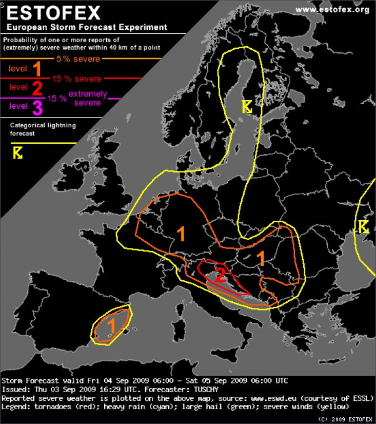
A level 1 was issued for parts of Germany, Netherlands, Belgium, Luxembourg and Switzerland, parts of Austria, Hungary, E-Slovakia, W-Ukraine, W-Romania and most parts of the Balkans mainly for large hail and severe wind gusts.
DISCUSSION: Belgium, the Netherlands, Luxembourg, eastern France and Germany
The main story during the forecast is the passage of the trough axis and attendant pool of cold mid-level air and the passage of a wave at lower levels (in high gear below 3km). Both features are displaced in time by a few hours, so thunderstorms are forecast in numerous waves and at different places.
The wave is placed over eastern France (roughly 9 UTC), over southern Germany at 12-15 UTC and over the Czech Republic at 18 UTC (based on GFS with ECMWF a tad slower). Both models show potential for thunderstorms, probably deep with cool EML temperatures in GFS. Initiation will be probably bound to the eastward moving cold front with isolated showers/thunderstorms in the weakly capped prefrontal warm sector. A potential scenario is an active, eastward racing cold front with embedded thunderstorms. Degree of shear especially at low levels points to an organized line (LEWP) with a severe wind gust threat. This line ought to decrease in intensity over N-Austria and the Czech Republic during the late evening hours, as CAPE decreases. Timing of this wave is important in respect of how unstable the airmass will be, which finally affects the magnitude of the wind gust risk. Next to that dominant risk, isolated tornadoes and marginal hail can't be ruled out, given degree of shear and some LL CAPE release.
Another area of interst includes Belgium, the Netherlands, Luxembourg and most parts of Germany during the daytime hours. As cold mid-levels overspread those areas from the west, steep lapse rates and adequate surface moisture result in at least modest CAPE release (up to 500 J/kg MLCAPE). Shear decreases gradually to the north, but remains supportive for organized thunderstorms with a hail and wind gust risk. An isolated tornado risk is present due to some directional shear and low LCLs, but the overall risk remains low as directional shear component first increases as CAPE decreases (evening and night hours). Thunderstorms decay after sunset.
Thunderstorm coverage is on the increase over the Baltic Sea during the night hours, as cold thermal trough overspreads the warmer Sea. Moderate CAPE with abundant LL CAPE release but weak shear point to an isolated waterspout risk, althoug no convergence zone can be seen in the models, which could serve as a focus for enhanced spout chances.
The same for the southern North Sea, where a few spouts are possible well in the night hours, although overall set-up does not look too promising with decreasing moisture content and no organized "convective lines" due to the late passage of a backbend occlusion (18-21 UTC).
©Estofex

 Onweerskansen van 1,2,3 en 4 september


