Live Bliksemontladingen

De teller in het icoon met het onweersbuitje geeft live het actuele aantal bliksemontladingen uit onze regio weer. De dekking ligt in een vierkant om Nederland en België, waardoor er ook data van rondom Parijs, op de Noordzee en uit een deel van Duitsland wordt weergegeven.

Ontladingen

De ontladingen kun je terugvinden op de Google Maps kaart onderaan de pagina. Deze worden nog niet live bijgewerkt, voor de meest actuele ontladingen ververs je de pagina. De iconen op de kaart lopen in kleur van Geel naar Rood, waarbij Geel een 'nieuwe' ontlading is en Rood een 'oude'.

Geluid

De teller maakt geluid als het aantal bliksemontladingen verhoogt. Dus, bij een update van 0 naar 1 hoor je geluid. Je kunt dit uitschakelen met het luidspreker icoontje in de balk hierboven.

Data © Blitzortung.org / Lightningmaps.org
nl
StormTrack Beta
Inloggen
Heb je nog geen account? Dan kun je er hier eentje aanmaken!
De Bilt

Geen onweer in de buurt
Nu Live

Er zijn de afgelopen 3 uur 500 ontladingen geregistreerd.

22 Dec 2024 10:16:43

De temperatuur bij Mont rigi is onder het vriespunt gekomen met voldoende luchtvochtigheid. Er is kans op gladheid in deze regio!

20 Dec 2024 14:41:58
Actueel
1 / 4

Het klets- en waarneemtopic

Deel jouw weerwaarneming!

De OnweerOnline stormtracker

Bekijk de radar en volg het onweer

Het Zomerdiscussietopic

Lees en schrijf mee!

Wateroverlast

Bijzonder nat afgelopen jaar achter de rug

×
Kies een plaats
Beschikbare Plaatsen:
×
Welke meldingen wil je ontvangen?

Je kunt hieronder aangeven welke notificaties je wil ontvangen in 'Nu Live'. Standaard ontvang je alle notificaties, wil je een bepaald type melding niet langer ontvangen? Vink dan het vinkje uit. Je keuze wordt automatisch opgeslagen.

×
Nu Live
Welkom op onweer-online.nl! Als je je nog niet hebt geregistreerd, meld je dan nu aan op de leukste en grootste weercommunity van Nederland. Heb je al een account, log dan hier in.
Woonplaats:
Berichten: 0
Lid sinds: 10 jun. 2007
25 augustus 2009, 12:23 uur | Bericht #49387
Upwards lightning caught on film

Scientists have photographed "upwards lightning", a rarely-seen phenomenon where electricity from storms flows into the upper atmosphere. During last year's Tropical Storm Cristobal, lightning reached more than 60km (40 miles) up. Also known as "gigantic jets", these events are just as powerful as cloud-to-ground lightning bolts. The US team of researchers also took radio measurements of the electrical charge.


The phenomenon was photographed from a field site near Duke University in Durham, North Carolina. Their work, published in Nature Geoscience, gives scientists a better understanding of this form of lightning. Gigantic jets do not occur during every storm and scientists do not yet know what types of storm are conducive to their formation.

Substantial charge
Lead author Professor Steven Cummer, from Duke, told BBC News: "What we were able to conclusively show is that these are not just sparks that come out of the thunderstorm and travel upward and tickle the upper atmosphere. They actually deliver to the upper atmosphere as much electric charge as the very strong lightning strokes to ground. The jets discharge a comparable amount of electricity to conventional lightning but the charge travels further and faster because the thinner air between the clouds and the ionosphere provides less resistance.
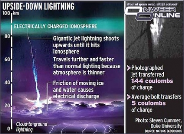


Gigantic jets are rarely photographed because they happen so quickly that cameras have to be trained on them exactly when they occur. Professor Cummer caught the images of the event by chance. He had trained his camera on the sky above the storm, hoping to photograph another phenomenon known as "sprites". These are blue or red electrical discharges above storm clouds.

He is planning to install a low-light, high speed camera to capture colour images of gigantic jets, which could provide information about chemical processes and temperatures. He said: "In fact, this one that we reported came from a tropical storm not quite a hurricane.

"There is another hurricane bearing down on us that is about to hit the eastern seaboard of the US. You can be sure that we will be training our cameras on that, just in case we are lucky."

©BBC | Gewijzigd: 3 februari 2017, 08:54 uur, door Joyce.s
remkie
Lid
Woonplaats: Swifterbant
Berichten: 124
Lid sinds: 25 mei. 2009
25 augustus 2009, 17:42 uur | Bericht #49442
indrukwekkend dat da zo hoog komt
Waarom deze advertentie?
Richardus
Lid
Woonplaats: Groningen
Berichten: 1294
Lid sinds: 27 jun. 2009
25 augustus 2009, 18:07 uur | Bericht #49444
en dat het zo'n enorme lading aflevert aan de ionosfeer vast belangrijk voor de instandhouding van die laag
thijmco
Lid
Woonplaats:
Berichten: 1802
Lid sinds: 28 jul. 2008
25 augustus 2009, 18:52 uur | Bericht #49448
als die 2e afbeelding op schaal is .... dan zijn dat enorm hoge wolken..... pl/m 20 km
Terug naar boven
1 Gebruiker leest nu dit topic, onderverdeeld in 1 gast en 0 leden
Berichten
Er zijn in totaal 27.888 topics, welke bij elkaar 448.498 reacties hebben gekregen.
Leden
We zijn met 11.609 leden.
Het nieuwste lid is Goos.

Berichten
Je moet inloggen om je berichten te kunnen lezen.
Dit topic
1 mensen bekijken nu dit topic.

Record
Op 6 december 2010 om 11.29 uur waren er 2.792 mensen tegelijkertijd online op onweer-online!
Stats
Er zijn nu 496 mensen aan het browsen op het forum. 0 Daarvan zijn ingelogd.
Van die 496, lezen 4 mensen het topic "Onweerskansen 10 en 11 september".

Sponsors en partners

Actueel op OnweerOnline.nl

Het Zomerdiscussietopic

Lees en schrijf mee!

Het klets- en waarneemtopic

Deel jouw weerwaarneming!

De OnweerOnline stormtracker

Bekijk de radar en volg het onweer

Wateroverlast

Bijzonder nat afgelopen jaar achter de rug

© 2003 - 2024 onweer-online.nl   |   Alle rechten voorbehouden   |   Algemene gebruiksvoorwaarden