Live Bliksemontladingen

De teller in het icoon met het onweersbuitje geeft live het actuele aantal bliksemontladingen uit onze regio weer. De dekking ligt in een vierkant om Nederland en België, waardoor er ook data van rondom Parijs, op de Noordzee en uit een deel van Duitsland wordt weergegeven.

Ontladingen

De ontladingen kun je terugvinden op de Google Maps kaart onderaan de pagina. Deze worden nog niet live bijgewerkt, voor de meest actuele ontladingen ververs je de pagina. De iconen op de kaart lopen in kleur van Geel naar Rood, waarbij Geel een 'nieuwe' ontlading is en Rood een 'oude'.

Geluid

De teller maakt geluid als het aantal bliksemontladingen verhoogt. Dus, bij een update van 0 naar 1 hoor je geluid. Je kunt dit uitschakelen met het luidspreker icoontje in de balk hierboven.

Data © Blitzortung.org / Lightningmaps.org
nl
StormTrack Beta
Inloggen
Heb je nog geen account? Dan kun je er hier eentje aanmaken!
De Bilt

Geen onweer in de buurt
Nu Live

NWS: Severe Thunderstorm Warning uitgegeven voor Armstrong, PA; Clarion, PA; Forest, PA; Indiana, PA; Jefferson, PA.

22 Nov 2024 09:51:43

NWS: Severe Thunderstorm Warning uitgegeven voor Armstrong, PA; Fayette, PA; Indiana, PA; Westmoreland, PA.

22 Nov 2024 09:51:42

NWS: Severe Thunderstorm Warning uitgegeven voor Cambria, PA; Somerset, PA.

22 Nov 2024 09:51:42

De temperatuur bij Buzenol is onder het vriespunt gekomen met voldoende luchtvochtigheid. Er is kans op gladheid in deze regio!

22 Nov 2024 09:35:11

De temperatuur bij Mont rigi is onder het vriespunt gekomen met voldoende luchtvochtigheid. Er is kans op gladheid in deze regio!

22 Nov 2024 09:35:10

De temperatuur bij Humain is onder het vriespunt gekomen met voldoende luchtvochtigheid. Er is kans op gladheid in deze regio!

22 Nov 2024 01:05:39

De temperatuur bij Ernage is onder het vriespunt gekomen met voldoende luchtvochtigheid. Er is kans op gladheid in deze regio!

22 Nov 2024 00:58:33

De temperatuur bij Buzenol is onder het vriespunt gekomen met voldoende luchtvochtigheid. Er is kans op gladheid in deze regio!

22 Nov 2024 00:58:32

De temperatuur bij Mont rigi is onder het vriespunt gekomen met voldoende luchtvochtigheid. Er is kans op gladheid in deze regio!

22 Nov 2024 00:58:32

De temperatuur bij Retie is onder het vriespunt gekomen met voldoende luchtvochtigheid. Er is kans op gladheid in deze regio!

21 Nov 2024 19:12:49

De temperatuur bij Ukkel is onder het vriespunt gekomen met voldoende luchtvochtigheid. Er is kans op gladheid in deze regio!

21 Nov 2024 19:12:48

NWS: Severe Thunderstorm Warning uitgegeven voor Allegheny, PA; Butler, PA; Washington, PA.

21 Nov 2024 12:27:29

NWS: Tornado Warning uitgegeven voor Allegheny, PA; Westmoreland, PA.

21 Nov 2024 12:27:28

De temperatuur bij Buzenol is onder het vriespunt gekomen met voldoende luchtvochtigheid. Er is kans op gladheid in deze regio!

21 Nov 2024 08:43:07

De temperatuur bij Humain is onder het vriespunt gekomen met voldoende luchtvochtigheid. Er is kans op gladheid in deze regio!

21 Nov 2024 04:02:13
Actueel
1 / 4

De OnweerOnline stormtracker

Bekijk de radar en volg het onweer

Het Zomerdiscussietopic

Lees en schrijf mee!

Het klets- en waarneemtopic

Deel jouw weerwaarneming!

Wateroverlast

Bijzonder nat afgelopen jaar achter de rug

×
Kies een plaats
Beschikbare Plaatsen:
×
Welke meldingen wil je ontvangen?

Je kunt hieronder aangeven welke notificaties je wil ontvangen in 'Nu Live'. Standaard ontvang je alle notificaties, wil je een bepaald type melding niet langer ontvangen? Vink dan het vinkje uit. Je keuze wordt automatisch opgeslagen.

×
Nu Live
Welkom op onweer-online.nl! Als je je nog niet hebt geregistreerd, meld je dan nu aan op de leukste en grootste weercommunity van Nederland. Heb je al een account, log dan hier in.
talkyr86
Lid
Woonplaats: Apeldoorn
Berichten: 4311
Lid sinds: 7 aug. 2008
22 juni 2009, 09:18 uur | Bericht #34727
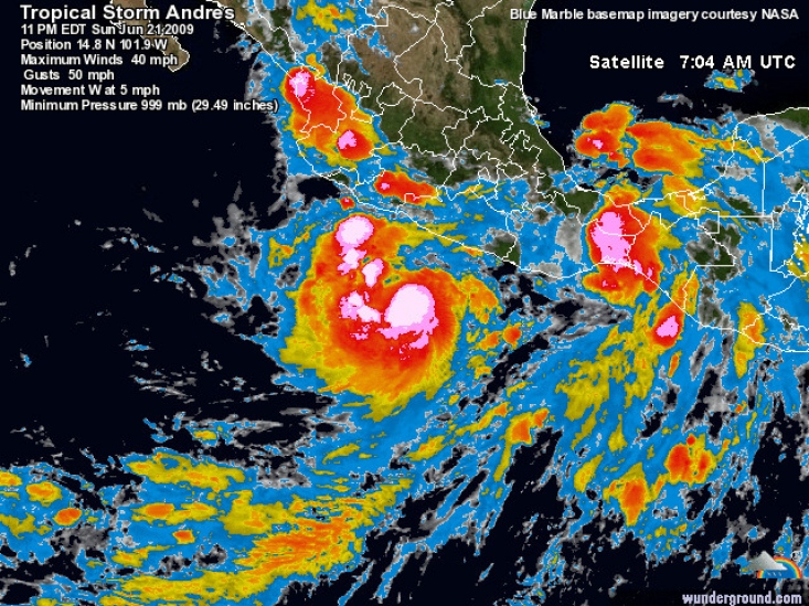
Tropical Storm Andres forms in Pacific off Mexico

Forecasters say Tropical Storm Andres has formed off the southwestern coast of Mexico, becoming the first named storm of the season in the Eastern Pacific.

Deze foto is niet meer beschikbaar

The government of Mexico has issued a tropical storm watch from Zihuatanejo northward to Manzanillo. The National Hurricane Center says the center of the storm as of 2 a.m. EDT Monday was about 200 miles (325 km) south of Zihuatanejo and 330 miles (530 km) south-southeast of Manzanillo.

Andres is moving slowly toward the west-northwest near 5 mph (7 kph). Maximum sustained winds are near 45 mph (65 kph) with higher gusts.Forecasters said the storm system could bring heavy rainfall to southwestern areas of Mexico over the next two days.

©AP
Woonplaats:
Berichten: 0
Lid sinds: 10 jun. 2007
22 juni 2009, 15:52 uur | Bericht #34754
Eerste tropische storm hangt voor kust van Mexico

Voor de Pacifische kust van Mexico hangt momenteel de allereerste tropische storm van dit seizoen, Andres genaamd. Het is voor het eerst in veertig jaar dat de eerste storm van het seizoen zo laat van zich laat horen. Het orkaanseizoen in de Grote Oceaan loopt gewoonlijk van half mei tot eind november, met het zwaartepunt tussen juli en september.

"Dat betekent echter niet dat het een kalm seizoen wordt", zegt Richard Pasch, een orkaanspecialist verbonden aan het National Hurricane Center in Miami, Florida. "We hebben nog al meegemaakt dat het seizoen traag op gang komt, maar dan in alle hevigheid losbarst. Het wordt gewoon afwachten."

Volgens voorspellingen van federale weerdeskundigen wordt het echter een min of meer normaal orkaanseizoen, met een achtiental tropische stormen, waarvan er zes tot tien kunnen uitgroeien tot een orkaan. Volgens de eerste weermodellen zal Andres het vasteland niet bereiken, maar kan de kust de komende twee dagen wel hevige regenbuien verwachten.

©Hln | Gewijzigd: 27 januari 2017, 12:55 uur, door Joyce.s
Waarom deze advertentie?
talkyr86
Lid
Woonplaats: Apeldoorn
Berichten: 4311
Lid sinds: 7 aug. 2008
23 juni 2009, 23:20 uur | Bericht #34912
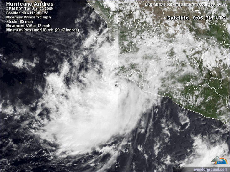
Hurricane Andres forms off Mexico's Pacific coast

Forecasters say Tropical Storm Andres has gained strength to become the first hurricane of the Pacific season. The National Hurricane Center said the hurricane off the southwestern coast of Mexico packed maximum winds near 75 mph. Andres is forecast to weaken during the next day or two. The center of the storm as of 5 p.m. EDT Tuesday was about 65 miles west-southwest of Manzanillo. Andres is moving near 13 mph toward the northwest. It is forecast to track toward the west-northwest and pass very close to or over the southwestern coast of Mexico later Tuesday.

Deze foto is niet meer beschikbaar

Tropical Storm Andres flooded homes and knocked down trees along Mexico's Pacific coast, killing at least one person as it headed toward a likely hurricane-force scrape with land on Tuesday. Mexico issued a hurricane warning for the strip of coast from just south of Manzanillo to near Puerto Vallarta. To the south, the storm dumped heavy rains on Acapulco, where flooding forced about 200 people to evacuate their homes on Monday.

A fisherman drowned when choppy currents overturned his boat in a lagoon Monday in Tecpan de Galeana, between Acapulco and Zihuatanejo, a state police report said. The sun peeked through cloudy skies in Acapulco on Tuesday, but the government closed all schools. Andres sped up as it headed on a course to graze the port city of Manzanillo at hurricane strength late Tuesday, then push along shore past towns such as Barra de Navidad that are home to some American and Canadian expatriates. Rain poured down on Manzanillo, where authorities opened 14 shelters.


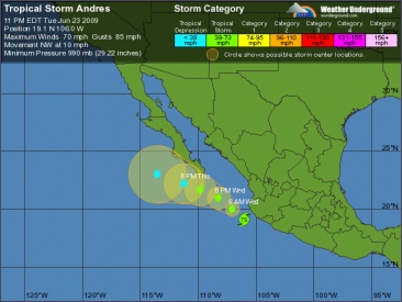
The U.S. National Hurricane Center said Andres could bring coastal storm surge as much as 3 feet (nearly 1 meter) above normal while dumping as much as 8 inches (200 millimeters) of rain in a few spots. The storm was centered about 55 miles (85 kilometers) south-southeast of Manzanillo at 11 a.m. PDT (2 p.m. EDT; 1700 GMT) Tuesday, and it had sustained winds near 70 mph (110 kph), with higher gusts. Tropical storm force winds extended out 70 miles (110 kilometers) from the center in some directions. It was moving toward the northwest near 12 mph (19 kph). The storm's winds were expected to build to 75 mph (120 kph), just over the minimum for a hurricane, by late Tuesday.

The forecast track showed it then weakening as it continues northwest along the coastline before veering west into the open Pacific and just south of the Los Cabos resorts at the tip of the Baja California peninsula Thursday morning. Late Sunday, Andres became the first named storm of the eastern Pacific hurricane season, which began May 15 and ends Nov. 30.

©AP | Gewijzigd: 24 juni 2009, 00:04 uur, door talkyr86
talkyr86
Lid
Woonplaats: Apeldoorn
Berichten: 4311
Lid sinds: 7 aug. 2008
24 juni 2009, 09:16 uur | Bericht #34955
Hurricane Andres pounds western Mexico, one dead

Deze foto is niet meer beschikbaar

Hurricane Andres, the first cyclone of the eastern Pacific season, pounded western Mexico on Tuesday after sweeping a fisherman to his death and flooding streets in Acapulco. Andres blew into a category one hurricane with sustained winds of 75 mph, coming close to Mexico's Pacific coast before easing in strength and turning northwest, the U.S. National Hurricane Center in Miami said. The storm, which was around 110 miles west of the port and resort town of Manzanillo, was downgraded back to a tropical storm.

©Reuters | Gewijzigd: 24 juni 2009, 09:17 uur, door talkyr86
Terug naar boven
1 Gebruiker leest nu dit topic, onderverdeeld in 1 gast en 0 leden
Berichten
Er zijn in totaal 27.880 topics, welke bij elkaar 448.478 reacties hebben gekregen.
Leden
We zijn met 11.606 leden.
Het nieuwste lid is AMV058.

Berichten
Je moet inloggen om je berichten te kunnen lezen.
Dit topic
1 mensen bekijken nu dit topic.

Record
Op 6 december 2010 om 11.29 uur waren er 2.792 mensen tegelijkertijd online op onweer-online!
Stats
Er zijn nu 605 mensen aan het browsen op het forum. 1 Daarvan zijn ingelogd.
Van die 605, lezen 25 mensen het topic "Waarnemingentopic Zomer 2015".

Sponsors en partners

Actueel op OnweerOnline.nl

De OnweerOnline stormtracker

Bekijk de radar en volg het onweer

Wateroverlast

Bijzonder nat afgelopen jaar achter de rug

Het Zomerdiscussietopic

Lees en schrijf mee!

Het klets- en waarneemtopic

Deel jouw weerwaarneming!

© 2003 - 2024 onweer-online.nl   |   Alle rechten voorbehouden   |   Algemene gebruiksvoorwaarden