
6.1 magnitude quake hits off Philippines
A magnitude 6.1 earthquake has struck off the southern Philippine island of Mindanao on Sunday, the United States Geological Survey said. Local officials, however, say no damage or casualties are expected. The quake was centred 159 kilometres south east of General Santos and had a depth of 75 kilometres.
The temblor originated under the sea and was unlikely to cause any damage, said Renato Solidum, director at the Philippine Institute of Vulcanology and Seismology. Mr Solidum said his agency had recorded a minimal intensity 2 in each of the cities of Davao and General Santos.
About 1,600 people were killed and billions of pesos worth of property and infrastructure were destroyed when a 7.8-magnitude quake struck the northern part of the country's main Luzon island in July 1990, the last major earthquake in the country.
© abc

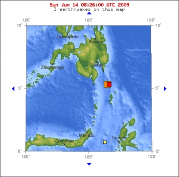
Magnitude 6.1
Date-Time
* Sunday, June 14, 2009 at 05:58:45 UTC
* Sunday, June 14, 2009 at 01:58:45 PM at epicenter
Location 5.415°N, 126.455°E
Depth 49.6 km (30.8 miles)
Region MINDANAO, PHILIPPINES
Distances
160 km (100 miles) ESE of General Santos, Mindanao, Philippines
205 km (130 miles) SSE of Davao, Mindanao, Philippines
1185 km (730 miles) SSE of MANILA, Philippines
2535 km (1570 miles) ENE of JAKARTA, Java, Indonesia

A magnitude 6.1 earthquake has struck off the southern Philippine island of Mindanao on Sunday, the United States Geological Survey said. Local officials, however, say no damage or casualties are expected. The quake was centred 159 kilometres south east of General Santos and had a depth of 75 kilometres.
The temblor originated under the sea and was unlikely to cause any damage, said Renato Solidum, director at the Philippine Institute of Vulcanology and Seismology. Mr Solidum said his agency had recorded a minimal intensity 2 in each of the cities of Davao and General Santos.
About 1,600 people were killed and billions of pesos worth of property and infrastructure were destroyed when a 7.8-magnitude quake struck the northern part of the country's main Luzon island in July 1990, the last major earthquake in the country.
© abc
Magnitude 6.1
Date-Time
* Sunday, June 14, 2009 at 05:58:45 UTC
* Sunday, June 14, 2009 at 01:58:45 PM at epicenter
Location 5.415°N, 126.455°E
Depth 49.6 km (30.8 miles)
Region MINDANAO, PHILIPPINES
Distances
160 km (100 miles) ESE of General Santos, Mindanao, Philippines
205 km (130 miles) SSE of Davao, Mindanao, Philippines
1185 km (730 miles) SSE of MANILA, Philippines
2535 km (1570 miles) ENE of JAKARTA, Java, Indonesia