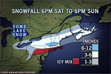
A winter storm will continue to strengthen early this morning, spreading heavy snow from Buffalo into the Boston area and crippling travel along the corridor between the two cities. The storm dumped 12 inches of snow in Chicago Friday through Saturday, and over 5 inches in Detroit.

The storm ramped up Saturday after tapping into moisture from the Gulf of Mexico. By this morning, the storm's center will shift from the Ohio Valley to the southern New England coast. The clash of very cold air to the north and milder air surging ahead of the storm is fueling the blossoming area of snow early this morning.
At times, the snow will come down at the rate of 1 to 2 inches per hour, resulting in a quick cover of snow on roads, poor visibility and dangerous travel conditions. Flight delays and cancellations can also be expected with the snow. Meanwhile, a thin corridor of an icy mix will fall to the south of the snow early this morning, from along the Mason-Dixon Line to the southern New England coast, creating treacherous travel conditions. In New York City, a mix of sleet and freezing rain will fall for a time.

The heaviest snow early this morning will fall from central New York into Massachusetts with 6 to 12 inches in the forecast. Snow falling across the Boston area is expected to accumulate 3 to 6 inches. The system will depart from New England today, ending the snow across the area by midday or the early afternoon.
©Accuweather

 Zware sneeuwval opweg naar New England


