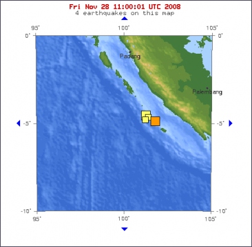
A magnitude 6.0 earthquake struck off Indonesia's Sumatra island on Friday, the U.S. Geological Survey said, although there was no tsunami warning or reports of damage or casualties. The quake was centered 141 km (88 miles) south southwest of Bengkulu city at a depth of 35 km, the agency said in a bulletin on its website.
An official at Indonesia's meteorology agency said the quake could be felt in Bengkulu and Lampung provinces in southern Sumatra, but there was no report of damage or casualties. Indonesia suffers frequent earthquakes lying in an extremely active seismic area where several tectonic plates collide.
Last week, several strong earthquakes also struck off Bengkulu and a more powerful earthquake hit northern Sulawesi, killing at least six people.
The sprawling archipelago of more than 17,000 islands was hit by a devastating tsunami four years ago that left an estimated 170,000 people dead or missing in Aceh province.
©Reuters
Deze foto is niet meer beschikbaar
Magnitude 6.0
Date-Time
* Friday, November 28, 2008 at 08:50:48 UTC
* Friday, November 28, 2008 at 03:50:48 PM at epicenter
Location 4.747°S, 101.744°E
Depth 23 km (14.3 miles) set by location program
Region SOUTHERN SUMATRA, INDONESIA
Distances
125 km (75 miles) SSW of Bengkulu, Sumatra, Indonesia
385 km (240 miles) WSW of Palembang, Sumatra, Indonesia
410 km (255 miles) SSW of Jambi, Sumatra, Indonesia
575 km (355 miles) WNW of JAKARTA, Java, Indonesia
Deze foto is niet meer beschikbaar Deze foto is niet meer beschikbaar

 Aardbeving van 6.0 bij Sumatra


 Deze foto is niet meer beschikbaar


